Silves geodata
Silves (Faro) is a seat of a second-order administrative division; located in Portugal in Europe/Lisbon (GMT+1) time zone. With population of 10,917 people, there are 200 cities with bigger population in this country. Compared to other cities in Portugal, 90.7% of cities are located further ↑North; 59.5% of cities are located further ←West and 82.9% of cities have higher elevation than Silves. Note1


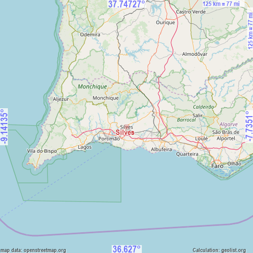
Silves GPS coordinates[2]
37° 11' 21.156" North, 8° 26' 17.592" West
| Map corner | latitude | longitude |
|---|---|---|
| Upper-left | 37.74727°, | -9.14135° |
| Center: | 37.18921°, | -8.43822° |
| Lower-right: | 36.627°, | -7.7351° |
| Map W x H: | 124.6×124.6 km | = 77.4×77.4mi |
| max Lat: | 42.11337° ⇑90.7% North |
| Silves: | 37.18921° |
| min Lat: | ⇓9.3% South 32.6448° |
| min Long | Silves | max Long |
| -31.17847° | -8.43822° | -6.27308° |
| W 59.5%⇐ | ⇒40.5% E |
Elevation
Elevation of Silves is 27 m = 89 ft, and this is 150 m = 492 ft below average elevation for this country.
| Max E: |
1008 m = 3307 ft | 82.9% |
| Avg. | 177 m = 581 ft | |
| Silves | 27 m = 89 ft | |
Min E: |
-128 m = -420 ft | 17.1% |
See also: Portugal elevation on elevation.city.
Geographical zone
Silves is located in North temperate zone (between Tropic of Cancer and the Arctic Circle). Distance of this Northern Tropic circle is 1529.1 km =950.1 mi to South.| Distance of | km | miles | from Silves |
|---|---|---|---|
| North Pole | 5872 | 3648.7 | to North |
| Arctic Circle | 3266.1 | 2029.5 | to North |
| Tropic Cancer | 1529.1 | 950.1 | to South |
| Equator | 4135.1 | 2569.4 | to South |


Nearby cities:
15 places around Silves: (largest is in red/bold)
• Alcantarilha
10.4 km =6.5 mi,  128°
128°
• Algoz
12.3 km =7.6 mi,  103°
103°
• Alvor
15.1 km =9.4 mi,  244°
244°
• Armação de Pêra
12 km =7.5 mi,  143°
143°
• Carvoeiro
10.6 km =6.6 mi,  194°
194°
• Estômbar
6.3 km =3.9 mi,  221°
221°
• Ferragudo
10.1 km =6.3 mi,  225°
225°
• Guia
14 km =8.7 mi,  118°
118°
• Lagoa
6.1 km =3.8 mi, 192°
• Mexilhoeira Grande
16 km =9.9 mi,  257°
257°
• Parchal
9 km =5.6 mi, 230°
• Porches
7.7 km =4.8 mi,  155°
155°
• Portimão
10.5 km =6.5 mi, 237°
• Pêra
11.3 km =7 mi, 130°
• São Bartolomeu de Messines
15.4 km =9.6 mi,  60°
60°
Sources, notices
• [Note1] Compared only with cities in Portugal existing in our database
• [Src1] Map data: © OpenStreetMap contributors (CC-BY-SA)
• [Src2] Other city data from geonames.org with taken over terms of usage.
• [Src3] Geographical zone / Annual Mean Temperature by Robert A. Rohde @ Wikipedia
