Armação de Pêra geodata
Armação de Pêra (Faro) is a populated place; located in Portugal in Europe/Lisbon (GMT+1) time zone. With population of 4,030 people, there are 516 cities with bigger population in this country. Compared to other cities in Portugal, 94% of cities are located further ↑North; 65.8% of cities are located further ←West and 96.7% of cities have higher elevation than Armação de Pêra. Note1


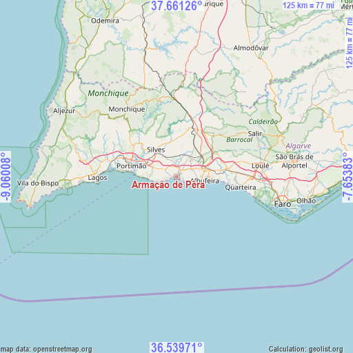
Armação de Pêra GPS coordinates[2]
37° 6' 9.216" North, 8° 21' 25.02" West
| Map corner | latitude | longitude |
|---|---|---|
| Upper-left | 37.66126°, | -9.06008° |
| Center: | 37.10256°, | -8.35695° |
| Lower-right: | 36.53971°, | -7.65383° |
| Map W x H: | 124.7×124.7 km | = 77.5×77.5mi |
| max Lat: | 42.11337° ⇑94% North |
| Armação de Pêra: | 37.10256° |
| min Lat: | ⇓6% South 32.6448° |
| min Long | Armação de P� | max Long |
| -31.17847° | -8.35695° | -6.27308° |
| W 65.8%⇐ | ⇒34.2% E |
Elevation
Elevation of Armação de Pêra is 8 m = 26 ft, and this is 169 m = 554 ft below average elevation for this country.
| Max E: |
1008 m = 3307 ft | 96.7% |
| Avg. | 177 m = 581 ft | |
| Armação de Pêra | 8 m = 26 ft | |
Min E: |
-128 m = -420 ft | 3.3% |
See also: Portugal elevation on elevation.city.
Geographical zone
Armação de Pêra is located in North temperate zone (between Tropic of Cancer and the Arctic Circle). Distance of this Northern Tropic circle is 1519.5 km =944.2 mi to South.| Distance of | km | miles | from Armação de Pêra |
|---|---|---|---|
| North Pole | 5881.6 | 3654.7 | to North |
| Arctic Circle | 3275.8 | 2035.5 | to North |
| Tropic Cancer | 1519.5 | 944.2 | to South |
| Equator | 4125.4 | 2563.4 | to South |


Nearby cities:
15 places around Armação de Pêra: (largest is in red/bold)
• Albufeira
9.6 km =6 mi,  99°
99°
• Alcantarilha
3.2 km =2 mi,  17°
17°
• Algoz
8.2 km =5.1 mi,  35°
35°
• Carvoeiro
9.9 km =6.2 mi,  266°
266°
• Estômbar
12.4 km =7.7 mi,  293°
293°
• Ferragudo
14.6 km =9.1 mi,  279°
279°
• Ferreiras
11 km =6.8 mi,  74°
74°
• Guia
5.9 km =3.7 mi,  59°
59°
• Lagoa
9.3 km =5.8 mi, 293°
• Olhos de Água
14.7 km =9.1 mi, 95°
• Parchal
14.7 km =9.1 mi, 285°
• Porches
4.8 km =3 mi,  304°
304°
• Pêra
2.7 km =1.7 mi,  31°
31°
• Silves
12 km =7.5 mi,  323°
323°
• Tunes
11.2 km =7 mi,  50°
50°
Sources, notices
• [Note1] Compared only with cities in Portugal existing in our database
• [Src1] Map data: © OpenStreetMap contributors (CC-BY-SA)
• [Src2] Other city data from geonames.org with taken over terms of usage.
• [Src3] Geographical zone / Annual Mean Temperature by Robert A. Rohde @ Wikipedia
