Carvoeiro geodata
Carvoeiro (Faro) is a populated place; located in Portugal in Europe/Lisbon (GMT+1) time zone. With population of 2,784 people, there are 596 cities with bigger population in this country. Compared to other cities in Portugal, 94.3% of cities are located further ↑North; 56.8% of cities are located further ←West and 72.9% of cities have higher elevation than Carvoeiro. Note1


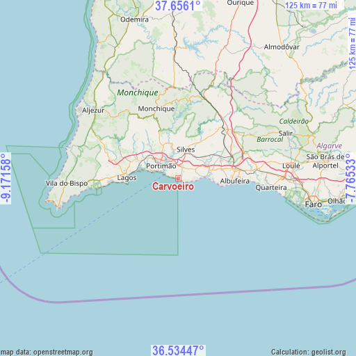
Carvoeiro GPS coordinates[2]
37° 5' 50.496" North, 8° 28' 6.456" West
| Map corner | latitude | longitude |
|---|---|---|
| Upper-left | 37.6561°, | -9.17158° |
| Center: | 37.09736°, | -8.46846° |
| Lower-right: | 36.53447°, | -7.76533° |
| Map W x H: | 124.7×124.7 km | = 77.5×77.5mi |
| max Lat: | 42.11337° ⇑94.3% North |
| Carvoeiro: | 37.09736° |
| min Lat: | ⇓5.7% South 32.6448° |
| min Long | Carvoeiro | max Long |
| -31.17847° | -8.46846° | -6.27308° |
| W 56.8%⇐ | ⇒43.2% E |
Elevation
Elevation of Carvoeiro is 45 m = 148 ft, and this is 132 m = 433 ft below average elevation for this country.
| Max E: |
1008 m = 3307 ft | 72.9% |
| Avg. | 177 m = 581 ft | |
| Carvoeiro | 45 m = 148 ft | |
Min E: |
-128 m = -420 ft | 27.1% |
See also: Portugal elevation on elevation.city.
Geographical zone
Carvoeiro is located in North temperate zone (between Tropic of Cancer and the Arctic Circle). Distance of this Northern Tropic circle is 1518.9 km =943.8 mi to South.| Distance of | km | miles | from Carvoeiro |
|---|---|---|---|
| North Pole | 5882.2 | 3655 | to North |
| Arctic Circle | 3276.3 | 2035.8 | to North |
| Tropic Cancer | 1518.9 | 943.8 | to South |
| Equator | 4124.8 | 2563 | to South |


Nearby cities:
15 places around Carvoeiro: (largest is in red/bold)
• Alcantarilha
11.4 km =7.1 mi,  71°
71°
• Algoz
16.3 km =10.1 mi,  63°
63°
• Alvor
11.5 km =7.1 mi,  288°
288°
• Armação de Pêra
9.9 km =6.2 mi,  86°
86°
• Estômbar
5.6 km =3.5 mi,  344°
344°
• Ferragudo
5.4 km =3.4 mi,  304°
304°
• Guia
15.4 km =9.6 mi,  76°
76°
• Lagoa
4.4 km =2.7 mi,  17°
17°
• Lagos
18.3 km =11.4 mi,  271°
271°
• Mexilhoeira Grande
14.7 km =9.1 mi, 297°
• Parchal
6.3 km =3.9 mi,  316°
316°
• Porches
6.8 km =4.2 mi, 61°
• Portimão
7.7 km =4.8 mi,  306°
306°
• Pêra
11.6 km =7.2 mi, 75°
• Silves
10.6 km =6.6 mi,  14°
14°
Sources, notices
• [Note1] Compared only with cities in Portugal existing in our database
• [Src1] Map data: © OpenStreetMap contributors (CC-BY-SA)
• [Src2] Other city data from geonames.org with taken over terms of usage.
• [Src3] Geographical zone / Annual Mean Temperature by Robert A. Rohde @ Wikipedia
