Mação geodata
Mação (Santarém) is a seat of a second-order administrative division; located in Portugal in Europe/Lisbon (GMT+1) time zone. In our database, there are 824 cities with bigger population. Compared to other cities in Portugal, 51.1% of cities are located further ↑North; 79.3% of cities are located further ←West and 82.5% of cities have lower elevation than Mação. Note1


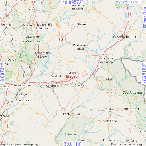
Mação GPS coordinates[2]
39° 33' 20.628" North, 7° 59' 39.156" West
| Map corner | latitude | longitude |
|---|---|---|
| Upper-left | 40.09572°, | -8.69734° |
| Center: | 39.55573°, | -7.99421° |
| Lower-right: | 39.0115°, | -7.29109° |
| Map W x H: | 120.6×120.6 km | = 74.9×74.9mi |
| max Lat: | 42.11337° ⇑51.1% North |
| Mação: | 39.55573° |
| min Lat: | ⇓48.9% South 32.6448° |
| min Long | Mação | max Long |
| -31.17847° | -7.99421° | -6.27308° |
| W 79.3%⇐ | ⇒20.7% E |
Elevation
Elevation of Mação is 315 m = 1033 ft, and this is 138 m = 453 ft above average elevation for this country.
| Max E: |
1008 m = 3307 ft | 17.5% |
| Mação | 315 m 1033 ft | |
| Avg. | 177 m = 581 ft | |
Min E: |
-128 m = -420 ft | 82.5% |
See also: Portugal elevation on elevation.city.
Geographical zone
Mação is located in North temperate zone (between Tropic of Cancer and the Arctic Circle). Distance of this Northern Tropic circle is 1792.3 km =1113.7 mi to South.| Distance of | km | miles | from Mação |
|---|---|---|---|
| North Pole | 5608.9 | 3485.2 | to North |
| Arctic Circle | 3003 | 1866 | to North |
| Tropic Cancer | 1792.3 | 1113.7 | to South |
| Equator | 4398.2 | 2732.9 | to South |


Nearby cities:
15 places around Mação: (largest is in red/bold)
• Abrantes
20.2 km =12.6 mi,  240°
240°
• Alferrarede
16.8 km =10.4 mi, 241°
• Atalaia
15.2 km =9.4 mi,  136°
136°
• Carvoeiro
9.8 km =6.1 mi,  38°
38°
• Comenda
25.2 km =15.7 mi,  133°
133°
• Fontes
21.1 km =13.1 mi,  285°
285°
• Gavião
11.4 km =7.1 mi,  153°
153°
• Martinchel
27.3 km =17 mi,  265°
265°
• Montalvo
27.4 km =17 mi,  252°
252°
• Pego
17 km =10.6 mi,  231°
231°
• Proença-a-Nova
22.7 km =14.1 mi,  15°
15°
• Sardoal
14.5 km =9 mi,  260°
260°
• São Miguel de Rio Torto
23.4 km =14.5 mi, 234°
• Tramagal
24.9 km =15.5 mi, 241°
• Vila de Rei
18.6 km =11.6 mi,  315°
315°
Sources, notices
• [Note1] Compared only with cities in Portugal existing in our database
• [Src1] Map data: © OpenStreetMap contributors (CC-BY-SA)
• [Src2] Other city data from geonames.org with taken over terms of usage.
• [Src3] Geographical zone / Annual Mean Temperature by Robert A. Rohde @ Wikipedia
