Atalaia geodata
Atalaia (Portalegre) is a populated place; located in Portugal in Europe/Lisbon (GMT+1) time zone. With population of 1,747 people, there are 668 cities with bigger population in this country. Compared to other cities in Portugal, 54.5% of cities are located further ↑North; 83.4% of cities are located further ←West and 77.8% of cities have lower elevation than Atalaia. Note1


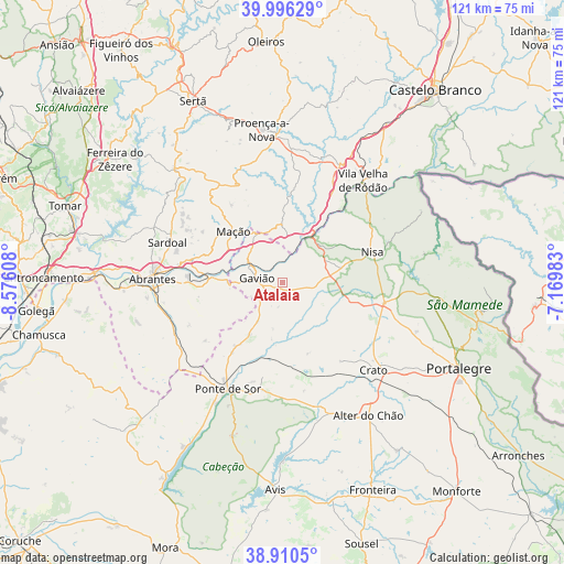
Atalaia GPS coordinates[2]
39° 27' 19.836" North, 7° 52' 22.62" West
| Map corner | latitude | longitude |
|---|---|---|
| Upper-left | 39.99629°, | -8.57608° |
| Center: | 39.45551°, | -7.87295° |
| Lower-right: | 38.9105°, | -7.16983° |
| Map W x H: | 120.7×120.7 km | = 75×75mi |
| max Lat: | 42.11337° ⇑54.5% North |
| Atalaia: | 39.45551° |
| min Lat: | ⇓45.5% South 32.6448° |
| min Long | Atalaia | max Long |
| -31.17847° | -7.87295° | -6.27308° |
| W 83.4%⇐ | ⇒16.6% E |
Elevation
Elevation of Atalaia is 261 m = 856 ft, and this is 84 m = 276 ft above average elevation for this country.
| Max E: |
1008 m = 3307 ft | 22.2% |
| Atalaia | 261 m 856 ft | |
| Avg. | 177 m = 581 ft | |
Min E: |
-128 m = -420 ft | 77.8% |
See also: Portugal elevation on elevation.city.
Geographical zone
Atalaia is located in North temperate zone (between Tropic of Cancer and the Arctic Circle). Distance of this Northern Tropic circle is 1781.1 km =1106.7 mi to South.| Distance of | km | miles | from Atalaia |
|---|---|---|---|
| North Pole | 5620 | 3492.1 | to North |
| Arctic Circle | 3014.1 | 1872.9 | to North |
| Tropic Cancer | 1781.1 | 1106.7 | to South |
| Equator | 4387 | 2726 | to South |


Nearby cities:
15 places around Atalaia: (largest is in red/bold)
• Abrantes
28.1 km =17.5 mi,  272°
272°
• Alagoa
30.5 km =19 mi,  110°
110°
• Alferrarede
25.4 km =15.8 mi,  276°
276°
• Carvoeiro
19.3 km =12 mi,  347°
347°
• Comenda
10 km =6.2 mi,  128°
128°
• Gavião
5.4 km =3.4 mi, 280°
• Gáfete
17 km =10.6 mi, 107°
• Mação
15.2 km =9.4 mi,  316°
316°
• Nisa
20.3 km =12.6 mi,  71°
71°
• Pego
23.8 km =14.8 mi, 271°
• Ponte de Sôr
25.7 km =16 mi,  207°
207°
• Póvoa e Meadas
31.1 km =19.3 mi,  78°
78°
• Sardoal
26.2 km =16.3 mi,  289°
289°
• São Miguel de Rio Torto
29.6 km =18.4 mi, 265°
• Vila Velha de Ródão
28 km =17.4 mi,  36°
36°
Sources, notices
• [Note1] Compared only with cities in Portugal existing in our database
• [Src1] Map data: © OpenStreetMap contributors (CC-BY-SA)
• [Src2] Other city data from geonames.org with taken over terms of usage.
• [Src3] Geographical zone / Annual Mean Temperature by Robert A. Rohde @ Wikipedia
