Carvoeiro geodata
Carvoeiro (Santarém) is a populated place; located in Portugal in Europe/Lisbon (GMT+1) time zone. With population of 794 people, there are 785 cities with bigger population in this country. Compared to other cities in Portugal, 50% of cities are located further ↓South; 81.4% of cities are located further ←West and 82.7% of cities have lower elevation than Carvoeiro. Note1


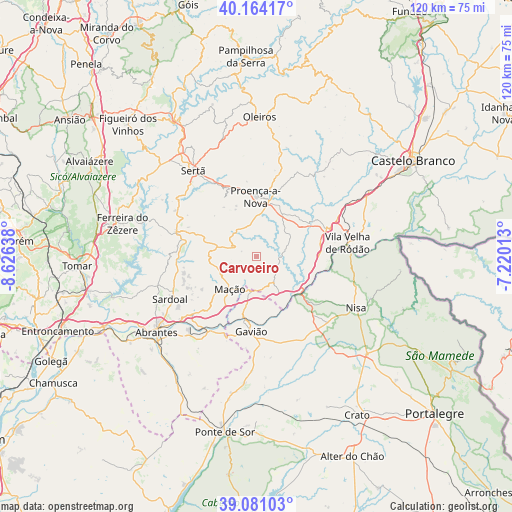
Carvoeiro GPS coordinates[2]
39° 37' 28.992" North, 7° 55' 23.7" West
| Map corner | latitude | longitude |
|---|---|---|
| Upper-left | 40.16417°, | -8.62638° |
| Center: | 39.62472°, | -7.92325° |
| Lower-right: | 39.08103°, | -7.22013° |
| Map W x H: | 120.4×120.4 km | = 74.8×74.8mi |
| max Lat: | 42.11337° ⇑50% North |
| Carvoeiro: | 39.62472° |
| min Lat: | ⇓50% South 32.6448° |
| min Long | Carvoeiro | max Long |
| -31.17847° | -7.92325° | -6.27308° |
| W 81.4%⇐ | ⇒18.6% E |
Elevation
Elevation of Carvoeiro is 317 m = 1040 ft, and this is 140 m = 459 ft above average elevation for this country.
| Max E: |
1008 m = 3307 ft | 17.3% |
| Carvoeiro | 317 m 1040 ft | |
| Avg. | 177 m = 581 ft | |
Min E: |
-128 m = -420 ft | 82.7% |
See also: Portugal elevation on elevation.city.
Geographical zone
Carvoeiro is located in North temperate zone (between Tropic of Cancer and the Arctic Circle). Distance of this Northern Tropic circle is 1799.9 km =1118.4 mi to South.| Distance of | km | miles | from Carvoeiro |
|---|---|---|---|
| North Pole | 5601.2 | 3480.4 | to North |
| Arctic Circle | 2995.3 | 1861.2 | to North |
| Tropic Cancer | 1799.9 | 1118.4 | to South |
| Equator | 4405.9 | 2737.7 | to South |


Nearby cities:
15 places around Carvoeiro: (largest is in red/bold)
• Abrantes
29.5 km =18.3 mi,  233°
233°
• Alferrarede
26.1 km =16.2 mi, 233°
• Atalaia
19.3 km =12 mi,  167°
167°
• Comenda
27.8 km =17.3 mi,  153°
153°
• Fontes
26.5 km =16.5 mi,  265°
265°
• Gavião
17.8 km =11.1 mi,  183°
183°
• Gáfete
31.4 km =19.5 mi,  139°
139°
• Mação
9.8 km =6.1 mi,  218°
218°
• Nisa
26.5 km =16.5 mi,  117°
117°
• Pego
26.6 km =16.5 mi, 226°
• Proença-a-Nova
14.2 km =8.8 mi,  359°
359°
• Sardoal
22.7 km =14.1 mi,  243°
243°
• Sertã
24.6 km =15.3 mi,  323°
323°
• Vila Velha de Ródão
21.4 km =13.3 mi,  80°
80°
• Vila de Rei
19.9 km =12.4 mi,  286°
286°
Sources, notices
• [Note1] Compared only with cities in Portugal existing in our database
• [Src1] Map data: © OpenStreetMap contributors (CC-BY-SA)
• [Src2] Other city data from geonames.org with taken over terms of usage.
• [Src3] Geographical zone / Annual Mean Temperature by Robert A. Rohde @ Wikipedia
