Proença-a-Nova geodata
Proença-a-Nova (Castelo Branco) is a seat of a second-order administrative division; located in Portugal in Europe/Lisbon (GMT+1) time zone. With population of 4,590 people, there are 461 cities with bigger population in this country. Compared to other cities in Portugal, 51.4% of cities are located further ↓South; 81.3% of cities are located further ←West and 89.8% of cities have lower elevation than Proença-a-Nova. Note1


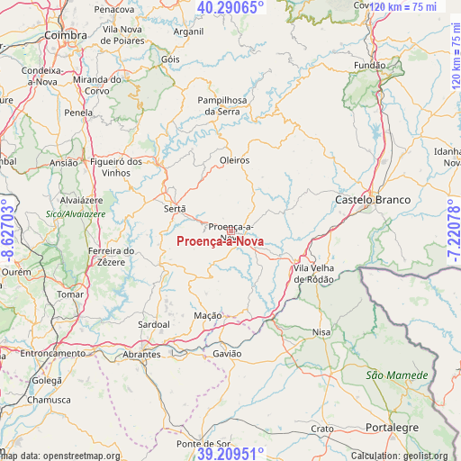
Proença-a-Nova GPS coordinates[2]
39° 45' 7.92" North, 7° 55' 26.04" West
| Map corner | latitude | longitude |
|---|---|---|
| Upper-left | 40.29065°, | -8.62703° |
| Center: | 39.7522°, | -7.9239° |
| Lower-right: | 39.20951°, | -7.22078° |
| Map W x H: | 120.2×120.2 km | = 74.7×74.7mi |
| max Lat: | 42.11337° ⇑48.6% North |
| Proença-a-Nova: | 39.7522° |
| min Lat: | ⇓51.4% South 32.6448° |
| min Long | Proença-a-Nova | max Long |
| -31.17847° | -7.9239° | -6.27308° |
| W 81.3%⇐ | ⇒18.7% E |
Elevation
Elevation of Proença-a-Nova is 464 m = 1522 ft, and this is 287 m = 942 ft above average elevation for this country.
| Max E: |
1008 m = 3307 ft | 10.2% |
| Proença-a-Nova | 464 m 1522 ft | |
| Avg. | 177 m = 581 ft | |
Min E: |
-128 m = -420 ft | 89.8% |
See also: Portugal elevation on elevation.city.
Geographical zone
Proença-a-Nova is located in North temperate zone (between Tropic of Cancer and the Arctic Circle). Distance of this Northern Tropic circle is 1814.1 km =1127.2 mi to South.| Distance of | km | miles | from Proença-a-Nova |
|---|---|---|---|
| North Pole | 5587 | 3471.6 | to North |
| Arctic Circle | 2981.1 | 1852.4 | to North |
| Tropic Cancer | 1814.1 | 1127.2 | to South |
| Equator | 4420 | 2746.5 | to South |


Nearby cities:
15 places around Proença-a-Nova: (largest is in red/bold)
• Atalaia
33.3 km =20.7 mi,  172°
172°
• Carvoeiro
14.2 km =8.8 mi,  179°
179°
• Ferreira do Zêzere
32.1 km =19.9 mi,  258°
258°
• Figueiró dos Vinhos
34.4 km =21.4 mi,  299°
299°
• Fontes
30.9 km =19.2 mi,  238°
238°
• Gavião
32 km =19.9 mi, 181°
• Mação
22.7 km =14.1 mi,  195°
195°
• Nisa
35.3 km =21.9 mi,  138°
138°
• Oleiros
18.6 km =11.6 mi,  2°
2°
• Pampilhosa da Serra
32.8 km =20.4 mi,  355°
355°
• Pedrógão Grande
26.5 km =16.5 mi,  314°
314°
• Sardoal
31.6 km =19.6 mi,  220°
220°
• Sertã
15.7 km =9.8 mi,  290°
290°
• Vila Velha de Ródão
23.7 km =14.7 mi,  116°
116°
• Vila de Rei
20.8 km =12.9 mi,  245°
245°
Sources, notices
• [Note1] Compared only with cities in Portugal existing in our database
• [Src1] Map data: © OpenStreetMap contributors (CC-BY-SA)
• [Src2] Other city data from geonames.org with taken over terms of usage.
• [Src3] Geographical zone / Annual Mean Temperature by Robert A. Rohde @ Wikipedia
