Portel geodata
Portel (Évora) is a seat of a second-order administrative division; located in Portugal in Europe/Lisbon (GMT+1) time zone. In our database, there are 824 cities with bigger population. Compared to other cities in Portugal, 82.1% of cities are located further ↑North; 87.8% of cities are located further ←West and 81.1% of cities have lower elevation than Portel. Note1


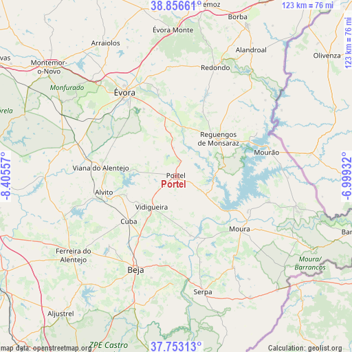
Portel GPS coordinates[2]
38° 18' 25.092" North, 7° 42' 8.784" West
| Map corner | latitude | longitude |
|---|---|---|
| Upper-left | 38.85661°, | -8.40557° |
| Center: | 38.30697°, | -7.70244° |
| Lower-right: | 37.75313°, | -6.99932° |
| Map W x H: | 122.7×122.7 km | = 76.2×76.2mi |
| max Lat: | 42.11337° ⇑82.1% North |
| Portel: | 38.30697° |
| min Lat: | ⇓17.9% South 32.6448° |
| min Long | Portel | max Long |
| -31.17847° | -7.70244° | -6.27308° |
| W 87.8%⇐ | ⇒12.2% E |
Elevation
Elevation of Portel is 297 m = 974 ft, and this is 120 m = 394 ft above average elevation for this country.
| Max E: |
1008 m = 3307 ft | 18.9% |
| Portel | 297 m 974 ft | |
| Avg. | 177 m = 581 ft | |
Min E: |
-128 m = -420 ft | 81.1% |
See also: Portugal elevation on elevation.city.
Geographical zone
Portel is located in North temperate zone (between Tropic of Cancer and the Arctic Circle). Distance of this Northern Tropic circle is 1653.4 km =1027.4 mi to South.| Distance of | km | miles | from Portel |
|---|---|---|---|
| North Pole | 5747.7 | 3571.5 | to North |
| Arctic Circle | 3141.8 | 1952.2 | to North |
| Tropic Cancer | 1653.4 | 1027.4 | to South |
| Equator | 4259.3 | 2646.6 | to South |


Nearby cities:
15 places around Portel: (largest is in red/bold)
• Alvito
25.9 km =16.1 mi,  257°
257°
• Beja
35.4 km =22 mi,  203°
203°
• Beringel
37.2 km =23.1 mi,  221°
221°
• Cuba
22.9 km =14.2 mi,  226°
226°
• Faro do Alentejo
27.3 km =17 mi, 229°
• Moura
28.9 km =18 mi,  129°
129°
• Mourão
32.6 km =20.3 mi,  74°
74°
• Neves
33.1 km =20.6 mi, 197°
• Reguengos de Monsaraz
19.7 km =12.2 mi,  47°
47°
• São Brissos
33.7 km =20.9 mi, 219°
• São Matias
25.8 km =16 mi,  211°
211°
• Trigaches
33.7 km =20.9 mi, 224°
• Viana do Alentejo
26.5 km =16.5 mi,  276°
276°
• Vidigueira
13.8 km =8.6 mi, 218°
• Évora
33.6 km =20.9 mi,  329°
329°
Sources, notices
• [Note1] Compared only with cities in Portugal existing in our database
• [Src1] Map data: © OpenStreetMap contributors (CC-BY-SA)
• [Src2] Other city data from geonames.org with taken over terms of usage.
• [Src3] Geographical zone / Annual Mean Temperature by Robert A. Rohde @ Wikipedia
