Santos-o-Velho geodata
Santos-o-Velho (Lisbon) is a section of populated place; located in Portugal in Europe/Lisbon (GMT+1) time zone. With population of 4,013 people, there are 521 cities with bigger population in this country. Compared to other cities in Portugal, 73.4% of cities are located further ↑North; 80.8% of cities are located further →East and 91.6% of cities have higher elevation than Santos-o-Velho. Note1


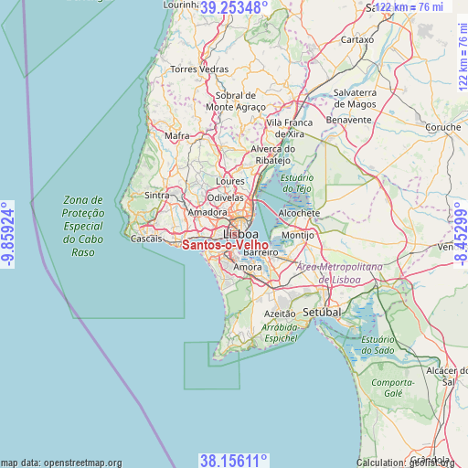
Santos-o-Velho GPS coordinates[2]
38° 42' 24.84" North, 9° 9' 21.996" West
| Map corner | latitude | longitude |
|---|---|---|
| Upper-left | 39.25348°, | -9.85924° |
| Center: | 38.7069°, | -9.15611° |
| Lower-right: | 38.15611°, | -8.45299° |
| Map W x H: | 122×122 km | = 75.8×75.8mi |
| max Lat: | 42.11337° ⇑73.4% North |
| Santos-o-Velho: | 38.7069° |
| min Lat: | ⇓26.6% South 32.6448° |
| min Long | Santos-o-Velho | max Long |
| -31.17847° | -9.15611° | -6.27308° |
| W 19.2%⇐ | ⇒80.8% E |
Elevation
Elevation of Santos-o-Velho is 14 m = 46 ft, and this is 163 m = 535 ft below average elevation for this country.
| Max E: |
1008 m = 3307 ft | 91.6% |
| Avg. | 177 m = 581 ft | |
| Santos-o-Velho | 14 m = 46 ft | |
Min E: |
-128 m = -420 ft | 8.4% |
See also: Portugal elevation on elevation.city.
Geographical zone
Santos-o-Velho is located in North temperate zone (between Tropic of Cancer and the Arctic Circle). Distance of this Northern Tropic circle is 1697.9 km =1055 mi to South.| Distance of | km | miles | from Santos-o-Velho |
|---|---|---|---|
| North Pole | 5703.3 | 3543.9 | to North |
| Arctic Circle | 3097.4 | 1924.6 | to North |
| Tropic Cancer | 1697.9 | 1055 | to South |
| Equator | 4303.8 | 2674.3 | to South |


Nearby cities:
15 places around Santos-o-Velho: (largest is in red/bold)
• Alfragide
6.1 km =3.8 mi,  297°
297°
• Algés
6.4 km =4 mi,  265°
265°
• Almada
3.1 km =1.9 mi,  181°
181°
• Alvalade
5.3 km =3.3 mi,  11°
11°
• Beato António
5.4 km =3.4 mi,  57°
57°
• Benfica
6.3 km =3.9 mi,  320°
320°
• Cacilhas
2.4 km =1.5 mi,  165°
165°
• Caparica
6.3 km =3.9 mi,  217°
217°
• Corroios
7.4 km =4.6 mi, 176°
• Laranjeira
5.7 km =3.5 mi, 177°
• Linda-a-Velha
7.5 km =4.7 mi,  276°
276°
• Lisbon
2.3 km =1.4 mi, 61°
• Piedade
4.1 km =2.5 mi, 182°
• Pragal
3.8 km =2.4 mi,  198°
198°
• Sobreda
7 km =4.3 mi, 204°
Sources, notices
• [Note1] Compared only with cities in Portugal existing in our database
• [Src1] Map data: © OpenStreetMap contributors (CC-BY-SA)
• [Src2] Other city data from geonames.org with taken over terms of usage.
• [Src3] Geographical zone / Annual Mean Temperature by Robert A. Rohde @ Wikipedia
