Cascais geodata
Cascais (Lisbon) is a populated place; located in Portugal in Europe/Lisbon (GMT+1) time zone. With population of 36,436 people, there are 33 cities with bigger population in this country. Compared to other cities in Portugal, 74.4% of cities are located further ↑North; 88.9% of cities are located further →East and 87.7% of cities have higher elevation than Cascais. Note1


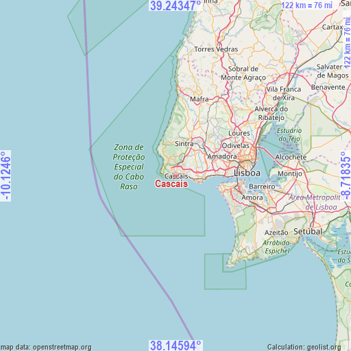
Cascais GPS coordinates[2]
38° 41' 48.516" North, 9° 25' 17.292" West
| Map corner | latitude | longitude |
|---|---|---|
| Upper-left | 39.24347°, | -10.1246° |
| Center: | 38.69681°, | -9.42147° |
| Lower-right: | 38.14594°, | -8.71835° |
| Map W x H: | 122×122 km | = 75.8×75.8mi |
| max Lat: | 42.11337° ⇑74.4% North |
| Cascais: | 38.69681° |
| min Lat: | ⇓25.6% South 32.6448° |
| min Long | Cascais | max Long |
| -31.17847° | -9.42147° | -6.27308° |
| W 11.1%⇐ | ⇒88.9% E |
Elevation
Elevation of Cascais is 20 m = 66 ft, and this is 157 m = 515 ft below average elevation for this country.
| Max E: |
1008 m = 3307 ft | 87.7% |
| Avg. | 177 m = 581 ft | |
| Cascais | 20 m = 66 ft | |
Min E: |
-128 m = -420 ft | 12.3% |
See also: Portugal elevation on elevation.city.
Geographical zone
Cascais is located in North temperate zone (between Tropic of Cancer and the Arctic Circle). Distance of this Northern Tropic circle is 1696.8 km =1054.3 mi to South.| Distance of | km | miles | from Cascais |
|---|---|---|---|
| North Pole | 5704.4 | 3544.5 | to North |
| Arctic Circle | 3098.5 | 1925.3 | to North |
| Tropic Cancer | 1696.8 | 1054.3 | to South |
| Equator | 4302.7 | 2673.6 | to South |


Nearby cities:
15 places around Cascais: (largest is in red/bold)
• Alcabideche
4.2 km =2.6 mi,  14°
14°
• Carcavelos
8.6 km =5.3 mi,  94°
94°
• Caxias
12.6 km =7.8 mi, 86°
• Colares
11.6 km =7.2 mi,  349°
349°
• Estoril
2.3 km =1.4 mi,  64°
64°
• Mem Martins
12.8 km =8 mi,  32°
32°
• Monte Estoril
1.7 km =1.1 mi,  51°
51°
• Oeiras
9.6 km =6 mi, 93°
• Parede
5.9 km =3.7 mi, 94°
• Paço de Arcos
11.3 km =7 mi, 90°
• Porto Salvo
10.5 km =6.5 mi,  74°
74°
• Rio de Mouro
11.2 km =7 mi, 46°
• Sintra
12.2 km =7.6 mi,  17°
17°
• São Domingos de Rana
7 km =4.3 mi, 85°
• Terrugem
11.7 km =7.3 mi,  84°
84°
Sources, notices
• [Note1] Compared only with cities in Portugal existing in our database
• [Src1] Map data: © OpenStreetMap contributors (CC-BY-SA)
• [Src2] Other city data from geonames.org with taken over terms of usage.
• [Src3] Geographical zone / Annual Mean Temperature by Robert A. Rohde @ Wikipedia
