Sintra geodata
Sintra (Lisbon) is a seat of a second-order administrative division; located in Portugal in Europe/Lisbon (GMT+0) time zone. With population of 26,193 people, there are 67 cities with bigger population in this country. Compared to other cities in Portugal, 68.9% of cities are located further ↑North; 88% of cities are located further →East and 68.9% of cities have lower elevation than Sintra. Note1
Administrative division(s):
- Level 1: Lisbon
- Level 2: Sintra
- Level 3: Sintra (Santa Maria e São Miguel)


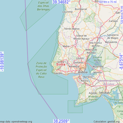
Sintra GPS coordinates[2]
38° 48' 3.492" North, 9° 22' 41.736" West
| Map corner | latitude | longitude |
|---|---|---|
| Upper-left | 39.34682°, | -10.08139° |
| Center: | 38.80097°, | -9.37826° |
| Lower-right: | 38.2509°, | -8.67514° |
| Map W x H: | 121.9×121.9 km | = 75.7×75.7mi |
| max Lat: | 42.11337° ⇑68.9% North |
| Sintra: | 38.80097° |
| min Lat: | ⇓31.1% South 32.6448° |
| min Long | Sintra | max Long |
| -31.17847° | -9.37826° | -6.27308° |
| W 12%⇐ | ⇒88% E |
Elevation
Elevation of Sintra is 197 m = 646 ft, and this is 20 m = 66 ft above average elevation for this country.
| Max E: |
1008 m = 3307 ft | 31.1% |
| Sintra | 197 m 646 ft | |
| Avg. | 177 m = 581 ft | |
Min E: |
-128 m = -420 ft | 68.9% |
See also: Portugal elevation on elevation.city.
Geographical zone
Sintra is located in North temperate zone (between Tropic of Cancer and the Arctic Circle). Distance of this Northern Tropic circle is 1708.3 km =1061.5 mi to South.| Distance of | km | miles | from Sintra |
|---|---|---|---|
| North Pole | 5692.8 | 3537.3 | to North |
| Arctic Circle | 3086.9 | 1918.1 | to North |
| Tropic Cancer | 1708.3 | 1061.5 | to South |
| Equator | 4314.3 | 2680.8 | to South |


Nearby cities:
15 places around Sintra: (largest is in red/bold)
• Alcabideche
8 km =5 mi,  199°
199°
• Algueirão
3 km =1.9 mi,  97°
97°
• Almargem
10.3 km =6.4 mi,  61°
61°
• Azenhas do Mar
8.3 km =5.2 mi,  302°
302°
• Belas
10.3 km =6.4 mi,  105°
105°
• Cacém
7.9 km =4.9 mi,  118°
118°
• Colares
6 km =3.7 mi,  268°
268°
• Estoril
10.7 km =6.6 mi,  189°
189°
• Fontanelas
7.4 km =4.6 mi,  314°
314°
• Massamá
10 km =6.2 mi, 122°
• Mem Martins
3.2 km =2 mi, 103°
• Pero Pinheiro
7.9 km =4.9 mi,  36°
36°
• Porto Salvo
10.8 km =6.7 mi,  143°
143°
• Rio de Mouro
5.8 km =3.6 mi,  131°
131°
• São João das Lampas
8.3 km =5.2 mi,  347°
347°
Sources, notices
• [Note1] Compared only with cities in Portugal existing in our database
• [Src1] Map data: © OpenStreetMap contributors (CC-BY-SA)
• [Src2] Other city data from geonames.org with taken over terms of usage.
• [Src3] Geographical zone / Annual Mean Temperature by Robert A. Rohde @ Wikipedia
