Alvorninha geodata
Alvorninha (Leiria) is a populated place; located in Portugal in Europe/Lisbon (GMT+1) time zone. With population of 2,987 people, there are 587 cities with bigger population in this country. Compared to other cities in Portugal, 56.7% of cities are located further ↑North; 75.6% of cities are located further →East and 53.2% of cities have lower elevation than Alvorninha. Note1


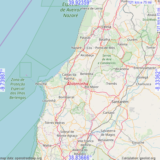
Alvorninha GPS coordinates[2]
39° 22' 56.064" North, 9° 2' 12.264" West
| Map corner | latitude | longitude |
|---|---|---|
| Upper-left | 39.92359°, | -9.73987° |
| Center: | 39.38224°, | -9.03674° |
| Lower-right: | 38.83666°, | -8.33362° |
| Map W x H: | 120.9×120.9 km | = 75.1×75.1mi |
| max Lat: | 42.11337° ⇑56.7% North |
| Alvorninha: | 39.38224° |
| min Lat: | ⇓43.3% South 32.6448° |
| min Long | Alvorninha | max Long |
| -31.17847° | -9.03674° | -6.27308° |
| W 24.4%⇐ | ⇒75.6% E |
Elevation
Elevation of Alvorninha is 123 m = 404 ft, and this is 54 m = 177 ft below average elevation for this country.
| Max E: |
1008 m = 3307 ft | 46.8% |
| Avg. | 177 m = 581 ft | |
| Alvorninha | 123 m = 404 ft | |
Min E: |
-128 m = -420 ft | 53.2% |
See also: Portugal elevation on elevation.city.
Geographical zone
Alvorninha is located in North temperate zone (between Tropic of Cancer and the Arctic Circle). Distance of this Northern Tropic circle is 1773 km =1101.7 mi to South.| Distance of | km | miles | from Alvorninha |
|---|---|---|---|
| North Pole | 5628.2 | 3497.2 | to North |
| Arctic Circle | 3022.3 | 1878 | to North |
| Tropic Cancer | 1773 | 1101.7 | to South |
| Equator | 4378.9 | 2720.9 | to South |


Nearby cities:
15 places around Alvorninha: (largest is in red/bold)
• A dos Francos
6.7 km =4.2 mi,  187°
187°
• Alfeizerão
14.3 km =8.9 mi,  336°
336°
• Benedita
7.4 km =4.6 mi,  50°
50°
• Bombarral
16.5 km =10.3 mi,  219°
219°
• Cadaval
16.5 km =10.3 mi,  200°
200°
• Caldas da Rainha
9 km =5.6 mi,  284°
284°
• Foz do Arelho
16.4 km =10.2 mi,  291°
291°
• Nadadouro
13.9 km =8.6 mi, 287°
• Rio Maior
9.8 km =6.1 mi,  120°
120°
• Salir de Matos
7.4 km =4.6 mi,  317°
317°
• Salir do Porto
16.2 km =10.1 mi, 320°
• Serra do Bouro
14.6 km =9.1 mi,  303°
303°
• Turquel
10.4 km =6.5 mi,  29°
29°
• Vidais
1.8 km =1.1 mi, 215°
• Óbidos
10.6 km =6.6 mi,  256°
256°
Sources, notices
• [Note1] Compared only with cities in Portugal existing in our database
• [Src1] Map data: © OpenStreetMap contributors (CC-BY-SA)
• [Src2] Other city data from geonames.org with taken over terms of usage.
• [Src3] Geographical zone / Annual Mean Temperature by Robert A. Rohde @ Wikipedia
