Pontével geodata
Pontével (Santarém) is a populated place; located in Portugal in Europe/Lisbon (GMT+1) time zone. With population of 4,435 people, there are 478 cities with bigger population in this country. Compared to other cities in Portugal, 61.3% of cities are located further ↑North; 69.8% of cities are located further →East and 68.2% of cities have higher elevation than Pontével. Note1


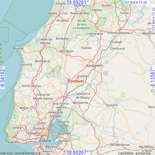
Pontével GPS coordinates[2]
39° 8' 58.02" North, 8° 50' 19.68" West
| Map corner | latitude | longitude |
|---|---|---|
| Upper-left | 39.69261°, | -9.54192° |
| Center: | 39.14945°, | -8.8388° |
| Lower-right: | 38.60207°, | -8.13567° |
| Map W x H: | 121.3×121.3 km | = 75.4×75.4mi |
| max Lat: | 42.11337° ⇑61.3% North |
| Pontével: | 39.14945° |
| min Lat: | ⇓38.7% South 32.6448° |
| min Long | Pontével | max Long |
| -31.17847° | -8.8388° | -6.27308° |
| W 30.2%⇐ | ⇒69.8% E |
Elevation
Elevation of Pontével is 54 m = 177 ft, and this is 123 m = 404 ft below average elevation for this country.
| Max E: |
1008 m = 3307 ft | 68.2% |
| Avg. | 177 m = 581 ft | |
| Pontével | 54 m = 177 ft | |
Min E: |
-128 m = -420 ft | 31.8% |
See also: Portugal elevation on elevation.city.
Geographical zone
Pontével is located in North temperate zone (between Tropic of Cancer and the Arctic Circle). Distance of this Northern Tropic circle is 1747.1 km =1085.6 mi to South.| Distance of | km | miles | from Pontével |
|---|---|---|---|
| North Pole | 5654.1 | 3513.3 | to North |
| Arctic Circle | 3048.2 | 1894.1 | to North |
| Tropic Cancer | 1747.1 | 1085.6 | to South |
| Equator | 4353 | 2704.8 | to South |


Nearby cities:
15 places around Pontével: (largest is in red/bold)
• Abrigada
15.5 km =9.6 mi,  267°
267°
• Alcoentre
12.3 km =7.6 mi,  302°
302°
• Alenquer
18.2 km =11.3 mi,  233°
233°
• Aveiras de Cima
5.4 km =3.4 mi,  256°
256°
• Azambuja
9.2 km =5.7 mi,  196°
196°
• Bemfica
13.1 km =8.1 mi,  93°
93°
• Carregado
18.4 km =11.4 mi,  220°
220°
• Cartaxo
4.6 km =2.9 mi,  74°
74°
• Marinhais
16.4 km =10.2 mi,  133°
133°
• Meca
18.5 km =11.5 mi,  245°
245°
• Ota
13.8 km =8.6 mi, 252°
• Salvaterra de Magos
14.1 km =8.8 mi,  163°
163°
• Santarém
16.3 km =10.1 mi,  55°
55°
• Vale de Santarém
10.6 km =6.6 mi, 64°
• Vila Chã de Ourique
6.7 km =4.2 mi, 67°
Sources, notices
• [Note1] Compared only with cities in Portugal existing in our database
• [Src1] Map data: © OpenStreetMap contributors (CC-BY-SA)
• [Src2] Other city data from geonames.org with taken over terms of usage.
• [Src3] Geographical zone / Annual Mean Temperature by Robert A. Rohde @ Wikipedia
