Ferragudo geodata
Ferragudo (Faro) is a populated place; located in Portugal in Europe/Lisbon (GMT+1) time zone. With population of 1,973 people, there are 650 cities with bigger population in this country. Compared to other cities in Portugal, 93.7% of cities are located further ↑North; 53.5% of cities are located further ←West and 98.2% of cities have higher elevation than Ferragudo. Note1


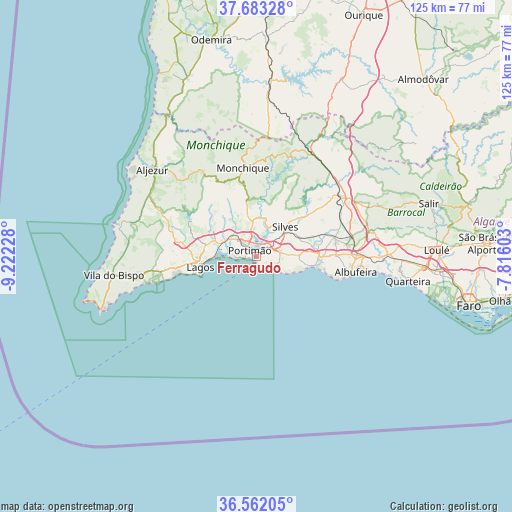
Ferragudo GPS coordinates[2]
37° 7' 29.064" North, 8° 31' 8.94" West
| Map corner | latitude | longitude |
|---|---|---|
| Upper-left | 37.68328°, | -9.22228° |
| Center: | 37.12474°, | -8.51915° |
| Lower-right: | 36.56205°, | -7.81603° |
| Map W x H: | 124.7×124.7 km | = 77.5×77.5mi |
| max Lat: | 42.11337° ⇑93.7% North |
| Ferragudo: | 37.12474° |
| min Lat: | ⇓6.3% South 32.6448° |
| min Long | Ferragudo | max Long |
| -31.17847° | -8.51915° | -6.27308° |
| W 53.5%⇐ | ⇒46.5% E |
Elevation
Elevation of Ferragudo is 5 m = 16 ft, and this is 172 m = 564 ft below average elevation for this country.
| Max E: |
1008 m = 3307 ft | 98.2% |
| Avg. | 177 m = 581 ft | |
| Ferragudo | 5 m = 16 ft | |
Min E: |
-128 m = -420 ft | 1.8% |
See also: Portugal elevation on elevation.city.
Geographical zone
Ferragudo is located in North temperate zone (between Tropic of Cancer and the Arctic Circle). Distance of this Northern Tropic circle is 1522 km =945.7 mi to South.| Distance of | km | miles | from Ferragudo |
|---|---|---|---|
| North Pole | 5879.2 | 3653.2 | to North |
| Arctic Circle | 3273.3 | 2033.9 | to North |
| Tropic Cancer | 1522 | 945.7 | to South |
| Equator | 4127.9 | 2565 | to South |


Nearby cities:
15 places around Ferragudo: (largest is in red/bold)
• Alcantarilha
15.3 km =9.5 mi,  87°
87°
• Alvor
6.5 km =4 mi,  275°
275°
• Armação de Pêra
14.6 km =9.1 mi,  99°
99°
• Carvoeiro
5.4 km =3.4 mi,  124°
124°
• Estômbar
3.9 km =2.4 mi,  51°
51°
• Guia
19.5 km =12.1 mi, 88°
• Lagoa
6 km =3.7 mi,  78°
78°
• Lagos
14 km =8.7 mi,  259°
259°
• Mexilhoeira Grande
9.3 km =5.8 mi,  293°
293°
• Parchal
1.5 km =0.9 mi,  7°
7°
• Porches
10.4 km =6.5 mi, 88°
• Portimão
2.3 km =1.4 mi,  312°
312°
• Pêra
15.8 km =9.8 mi, 90°
• Senhora da Luz
18.8 km =11.7 mi, 257°
• Silves
10.1 km =6.3 mi, 45°
Sources, notices
• [Note1] Compared only with cities in Portugal existing in our database
• [Src1] Map data: © OpenStreetMap contributors (CC-BY-SA)
• [Src2] Other city data from geonames.org with taken over terms of usage.
• [Src3] Geographical zone / Annual Mean Temperature by Robert A. Rohde @ Wikipedia
