Altura geodata
Altura (Faro) is a populated place; located in Portugal in Europe/Lisbon (GMT+1) time zone. With population of 2,195 people, there are 629 cities with bigger population in this country. Compared to other cities in Portugal, 91.1% of cities are located further ↑North; 92.2% of cities are located further ←West and 96.7% of cities have higher elevation than Altura. Note1


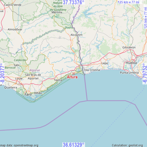
Altura GPS coordinates[2]
37° 10' 32.16" North, 7° 30' 2.304" West
| Map corner | latitude | longitude |
|---|---|---|
| Upper-left | 37.73376°, | -8.20377° |
| Center: | 37.1756°, | -7.50064° |
| Lower-right: | 36.61329°, | -6.79752° |
| Map W x H: | 124.6×124.6 km | = 77.4×77.4mi |
| max Lat: | 42.11337° ⇑91.1% North |
| Altura: | 37.1756° |
| min Lat: | ⇓8.9% South 32.6448° |
| min Long | Altura | max Long |
| -31.17847° | -7.50064° | -6.27308° |
| W 92.2%⇐ | ⇒7.8% E |
Elevation
Elevation of Altura is 8 m = 26 ft, and this is 169 m = 554 ft below average elevation for this country.
| Max E: |
1008 m = 3307 ft | 96.7% |
| Avg. | 177 m = 581 ft | |
| Altura | 8 m = 26 ft | |
Min E: |
-128 m = -420 ft | 3.3% |
See also: Portugal elevation on elevation.city.
Geographical zone
Altura is located in North temperate zone (between Tropic of Cancer and the Arctic Circle). Distance of this Northern Tropic circle is 1527.6 km =949.2 mi to South.| Distance of | km | miles | from Altura |
|---|---|---|---|
| North Pole | 5873.5 | 3649.6 | to North |
| Arctic Circle | 3267.6 | 2030.4 | to North |
| Tropic Cancer | 1527.6 | 949.2 | to South |
| Equator | 4133.5 | 2568.4 | to South |


Nearby cities:
15 places around Altura: (largest is in red/bold)
• Alcoutim
33.3 km =20.7 mi,  4°
4°
• Cabanas de Tavira
9.9 km =6.2 mi,  243°
243°
• Castro Marim
7.1 km =4.4 mi,  45°
45°
• Conceição
9.7 km =6 mi,  251°
251°
• Fuzeta
25.7 km =16 mi, 238°
• Laranjeiro
29.7 km =18.5 mi, 246°
• Luz
20.3 km =12.6 mi, 242°
• Manta Rota
1.7 km =1.1 mi, 242°
• Moncarapacho
27.4 km =17 mi, 248°
• Monte Gordo
4.3 km =2.7 mi,  80°
80°
• Olhão
34.3 km =21.3 mi, 241°
• Santa Luzia
16.5 km =10.3 mi, 240°
• Tavira
14.2 km =8.8 mi, 247°
• Vila Nova De Cacela
2.8 km =1.7 mi,  266°
266°
• Vila Real de Santo António
7.7 km =4.8 mi,  73°
73°
Sources, notices
• [Note1] Compared only with cities in Portugal existing in our database
• [Src1] Map data: © OpenStreetMap contributors (CC-BY-SA)
• [Src2] Other city data from geonames.org with taken over terms of usage.
• [Src3] Geographical zone / Annual Mean Temperature by Robert A. Rohde @ Wikipedia
