Vila Nova De Cacela geodata
Vila Nova De Cacela (Faro) is a populated place; located in Portugal in Europe/Lisbon (GMT+1) time zone. With population of 3,902 people, there are 530 cities with bigger population in this country. Compared to other cities in Portugal, 91.2% of cities are located further ↑North; 91.4% of cities are located further ←West and 77.4% of cities have higher elevation than Vila Nova De Cacela. Note1
Administrative division(s):
- Level 1: Faro
- Level 2: Vila Real de Santo António
- Level 3: Vila Nova de Cacela


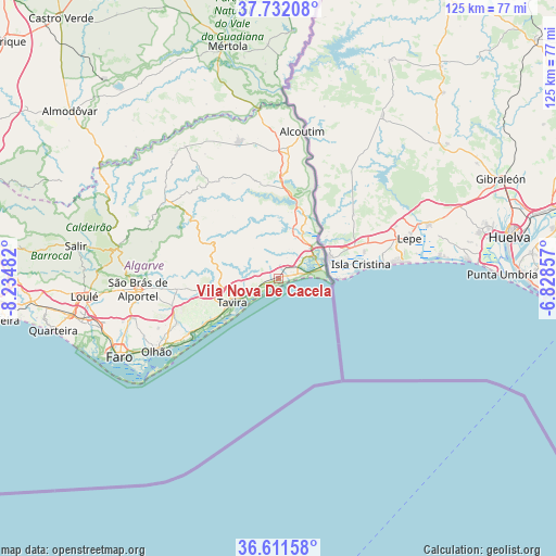
Vila Nova De Cacela GPS coordinates[2]
37° 10' 26.076" North, 7° 31' 54.084" West
| Map corner | latitude | longitude |
|---|---|---|
| Upper-left | 37.73208°, | -8.23482° |
| Center: | 37.17391°, | -7.53169° |
| Lower-right: | 36.61158°, | -6.82857° |
| Map W x H: | 124.6×124.6 km | = 77.4×77.4mi |
| max Lat: | 42.11337° ⇑91.2% North |
| Vila Nova De Cacela: | 37.17391° |
| min Lat: | ⇓8.8% South 32.6448° |
| min Long | Vila Nova De Ca | max Long |
| -31.17847° | -7.53169° | -6.27308° |
| W 91.4%⇐ | ⇒8.6% E |
Elevation
Elevation of Vila Nova De Cacela is 36 m = 118 ft, and this is 141 m = 463 ft below average elevation for this country.
| Max E: |
1008 m = 3307 ft | 77.4% |
| Avg. | 177 m = 581 ft | |
| Vila Nova De Cacela | 36 m = 118 ft | |
Min E: |
-128 m = -420 ft | 22.6% |
See also: Portugal elevation on elevation.city.
Geographical zone
Vila Nova De Cacela is located in North temperate zone (between Tropic of Cancer and the Arctic Circle). Distance of this Northern Tropic circle is 1527.4 km =949.1 mi to South.| Distance of | km | miles | from Vila Nova De Cacela |
|---|---|---|---|
| North Pole | 5873.7 | 3649.7 | to North |
| Arctic Circle | 3267.8 | 2030.5 | to North |
| Tropic Cancer | 1527.4 | 949.1 | to South |
| Equator | 4133.4 | 2568.4 | to South |


Nearby cities:
15 places around Vila Nova De Cacela: (largest is in red/bold)
• Altura
2.8 km =1.7 mi,  86°
86°
• Cabanas de Tavira
7.5 km =4.7 mi,  234°
234°
• Castro Marim
9.4 km =5.8 mi,  56°
56°
• Conceição
7.1 km =4.4 mi,  245°
245°
• Fuzeta
23.3 km =14.5 mi,  235°
235°
• Laranjeiro
27.2 km =16.9 mi, 244°
• Luz
17.8 km =11.1 mi, 239°
• Manta Rota
1.4 km =0.9 mi,  116°
116°
• Moncarapacho
24.8 km =15.4 mi, 246°
• Monte Gordo
7.1 km =4.4 mi,  82°
82°
• Olhão
31.8 km =19.8 mi, 239°
• Santa Luzia
14 km =8.7 mi, 235°
• São Brás de Alportel
31.6 km =19.6 mi,  265°
265°
• Tavira
11.6 km =7.2 mi, 243°
• Vila Real de Santo António
10.4 km =6.5 mi, 76°
Sources, notices
• [Note1] Compared only with cities in Portugal existing in our database
• [Src1] Map data: © OpenStreetMap contributors (CC-BY-SA)
• [Src2] Other city data from geonames.org with taken over terms of usage.
• [Src3] Geographical zone / Annual Mean Temperature by Robert A. Rohde @ Wikipedia
