Moncarapacho geodata
Moncarapacho (Faro) is a populated place; located in Portugal in Europe/Lisbon (GMT+1) time zone. With population of 8,545 people, there are 263 cities with bigger population in this country. Compared to other cities in Portugal, 95.2% of cities are located further ↑North; 85.5% of cities are located further ←West and 63.2% of cities have higher elevation than Moncarapacho. Note1


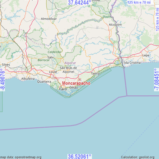
Moncarapacho GPS coordinates[2]
37° 5' 0.96" North, 7° 47' 15.468" West
| Map corner | latitude | longitude |
|---|---|---|
| Upper-left | 37.64244°, | -8.49076° |
| Center: | 37.0836°, | -7.78763° |
| Lower-right: | 36.52061°, | -7.08451° |
| Map W x H: | 124.7×124.7 km | = 77.5×77.5mi |
| max Lat: | 42.11337° ⇑95.2% North |
| Moncarapacho: | 37.0836° |
| min Lat: | ⇓4.8% South 32.6448° |
| min Long | Moncarapacho | max Long |
| -31.17847° | -7.78763° | -6.27308° |
| W 85.5%⇐ | ⇒14.5% E |
Elevation
Elevation of Moncarapacho is 68 m = 223 ft, and this is 109 m = 358 ft below average elevation for this country.
| Max E: |
1008 m = 3307 ft | 63.2% |
| Avg. | 177 m = 581 ft | |
| Moncarapacho | 68 m = 223 ft | |
Min E: |
-128 m = -420 ft | 36.8% |
See also: Portugal elevation on elevation.city.
Geographical zone
Moncarapacho is located in North temperate zone (between Tropic of Cancer and the Arctic Circle). Distance of this Northern Tropic circle is 1517.4 km =942.9 mi to South.| Distance of | km | miles | from Moncarapacho |
|---|---|---|---|
| North Pole | 5883.8 | 3656 | to North |
| Arctic Circle | 3277.9 | 2036.8 | to North |
| Tropic Cancer | 1517.4 | 942.9 | to South |
| Equator | 4123.3 | 2562.1 | to South |


Nearby cities:
15 places around Moncarapacho: (largest is in red/bold)
• Almancil
21.6 km =13.4 mi,  270°
270°
• Cabanas de Tavira
17.6 km =10.9 mi,  70°
70°
• Conceição
17.8 km =11.1 mi, 66°
• Estói
9.6 km =6 mi,  277°
277°
• Faro
14.3 km =8.9 mi,  239°
239°
• Fuzeta
4.9 km =3 mi,  132°
132°
• Laranjeiro
2.5 km =1.6 mi,  225°
225°
• Loulé
21.4 km =13.3 mi,  286°
286°
• Luz
7.4 km =4.6 mi,  82°
82°
• Olhão
7.7 km =4.8 mi,  217°
217°
• Santa Bárbara de Nexe
16.1 km =10 mi, 278°
• Santa Luzia
11.3 km =7 mi, 79°
• São Brás de Alportel
11.8 km =7.3 mi,  311°
311°
• Tavira
13.3 km =8.3 mi, 68°
• Vila Nova De Cacela
24.8 km =15.4 mi, 66°
Sources, notices
• [Note1] Compared only with cities in Portugal existing in our database
• [Src1] Map data: © OpenStreetMap contributors (CC-BY-SA)
• [Src2] Other city data from geonames.org with taken over terms of usage.
• [Src3] Geographical zone / Annual Mean Temperature by Robert A. Rohde @ Wikipedia
