Olhão geodata
Olhão (Faro) is a seat of a second-order administrative division; located in Portugal in Europe/Lisbon (GMT+1) time zone. With population of 29,239 people, there are 52 cities with bigger population in this country. Compared to other cities in Portugal, 95.8% of cities are located further ↑North; 84% of cities are located further ←West and 94.1% of cities have higher elevation than Olhão. Note1


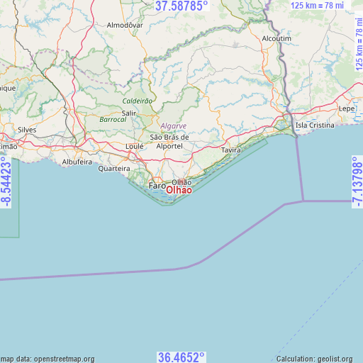
Olhão GPS coordinates[2]
37° 1' 42.96" North, 7° 50' 27.96" West
| Map corner | latitude | longitude |
|---|---|---|
| Upper-left | 37.58785°, | -8.54423° |
| Center: | 37.0286°, | -7.8411° |
| Lower-right: | 36.4652°, | -7.13798° |
| Map W x H: | 124.8×124.8 km | = 77.5×77.5mi |
| max Lat: | 42.11337° ⇑95.8% North |
| Olhão: | 37.0286° |
| min Lat: | ⇓4.2% South 32.6448° |
| min Long | Olhão | max Long |
| -31.17847° | -7.8411° | -6.27308° |
| W 84%⇐ | ⇒16% E |
Elevation
Elevation of Olhão is 11 m = 36 ft, and this is 166 m = 545 ft below average elevation for this country.
| Max E: |
1008 m = 3307 ft | 94.1% |
| Avg. | 177 m = 581 ft | |
| Olhão | 11 m = 36 ft | |
Min E: |
-128 m = -420 ft | 5.9% |
See also: Portugal elevation on elevation.city.
Geographical zone
Olhão is located in North temperate zone (between Tropic of Cancer and the Arctic Circle). Distance of this Northern Tropic circle is 1511.3 km =939.1 mi to South.| Distance of | km | miles | from Olhão |
|---|---|---|---|
| North Pole | 5889.9 | 3659.8 | to North |
| Arctic Circle | 3284 | 2040.6 | to North |
| Tropic Cancer | 1511.3 | 939.1 | to South |
| Equator | 4117.2 | 2558.3 | to South |


Nearby cities:
15 places around Olhão: (largest is in red/bold)
• Almancil
18 km =11.2 mi,  291°
291°
• Cabanas de Tavira
24.4 km =15.2 mi,  60°
60°
• Conceição
24.8 km =15.4 mi, 57°
• Estói
8.8 km =5.5 mi,  327°
327°
• Faro
7.7 km =4.8 mi,  261°
261°
• Fuzeta
8.8 km =5.5 mi,  71°
71°
• Laranjeiro
5.3 km =3.3 mi,  34°
34°
• Loulé
20 km =12.4 mi,  307°
307°
• Luz
14 km =8.7 mi, 59°
• Moncarapacho
7.7 km =4.8 mi,  37°
37°
• Quarteira
23.5 km =14.6 mi,  281°
281°
• Santa Bárbara de Nexe
14.1 km =8.8 mi, 307°
• Santa Luzia
17.9 km =11.1 mi, 62°
• São Brás de Alportel
14.4 km =8.9 mi,  343°
343°
• Tavira
20.3 km =12.6 mi, 57°
Sources, notices
• [Note1] Compared only with cities in Portugal existing in our database
• [Src1] Map data: © OpenStreetMap contributors (CC-BY-SA)
• [Src2] Other city data from geonames.org with taken over terms of usage.
• [Src3] Geographical zone / Annual Mean Temperature by Robert A. Rohde @ Wikipedia
