Vilar do Paraíso geodata
Vilar do Paraíso (Porto) is a populated place; located in Portugal in Europe/Lisbon (GMT+1) time zone. With population of 14,727 people, there are 143 cities with bigger population in this country. Compared to other cities in Portugal, 73.8% of cities are located further ↓South; 54.9% of cities are located further →East and 63.6% of cities have higher elevation than Vilar do Paraíso. Note1


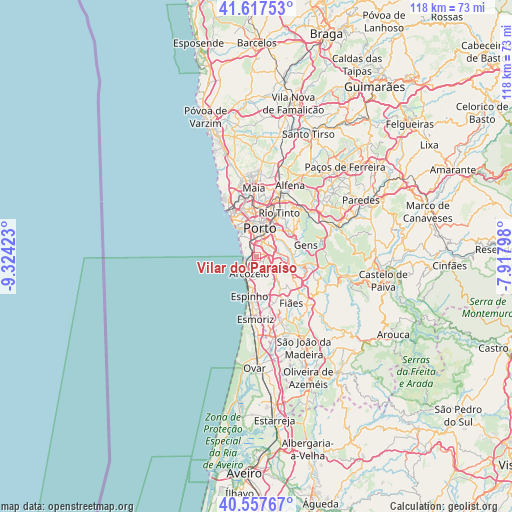
Vilar do Paraíso GPS coordinates[2]
41° 5' 23.064" North, 8° 37' 15.96" West
| Map corner | latitude | longitude |
|---|---|---|
| Upper-left | 41.61753°, | -9.32423° |
| Center: | 41.08974°, | -8.6211° |
| Lower-right: | 40.55767°, | -7.91798° |
| Map W x H: | 117.8×117.8 km | = 73.2×73.2mi |
| max Lat: | 42.11337° ⇑26.2% North |
| Vilar do Paraíso: | 41.08974° |
| min Lat: | ⇓73.8% South 32.6448° |
| min Long | Vilar do Paraí | max Long |
| -31.17847° | -8.6211° | -6.27308° |
| W 45.1%⇐ | ⇒54.9% E |
Elevation
Elevation of Vilar do Paraíso is 67 m = 220 ft, and this is 110 m = 361 ft below average elevation for this country.
| Max E: |
1008 m = 3307 ft | 63.6% |
| Avg. | 177 m = 581 ft | |
| Vilar do Paraíso | 67 m = 220 ft | |
Min E: |
-128 m = -420 ft | 36.4% |
See also: Portugal elevation on elevation.city.
Geographical zone
Vilar do Paraíso is located in North temperate zone (between Tropic of Cancer and the Arctic Circle). Distance of this Northern Tropic circle is 1962.8 km =1219.6 mi to South.| Distance of | km | miles | from Vilar do Paraíso |
|---|---|---|---|
| North Pole | 5438.3 | 3379.2 | to North |
| Arctic Circle | 2832.4 | 1760 | to North |
| Tropic Cancer | 1962.8 | 1219.6 | to South |
| Equator | 4568.8 | 2838.9 | to South |


Nearby cities:
15 places around Vilar do Paraíso: (largest is in red/bold)
• Arcozelo
3.2 km =2 mi,  196°
196°
• Avintes
6.2 km =3.9 mi,  71°
71°
• Azenha
1.5 km =0.9 mi,  191°
191°
• Canelas
1.9 km =1.2 mi,  111°
111°
• Canidelo
4.3 km =2.7 mi,  330°
330°
• Gulpilhares
0.9 km =0.6 mi,  212°
212°
• Oliveira do Douro
4.9 km =3 mi,  38°
38°
• Perozinho
4.1 km =2.5 mi,  132°
132°
• Sermonde
5.6 km =3.5 mi,  147°
147°
• Serzedo
4.3 km =2.7 mi,  174°
174°
• São Félix da Marinha
6 km =3.7 mi,  181°
181°
• Valbom
6.6 km =4.1 mi,  48°
48°
• Vila Nova da Telha
2.6 km =1.6 mi,  220°
220°
• Vila Nova de Gaia
3.9 km =2.4 mi,  10°
10°
• Vilar de Andorinho
3.4 km =2.1 mi,  58°
58°
Sources, notices
• [Note1] Compared only with cities in Portugal existing in our database
• [Src1] Map data: © OpenStreetMap contributors (CC-BY-SA)
• [Src2] Other city data from geonames.org with taken over terms of usage.
• [Src3] Geographical zone / Annual Mean Temperature by Robert A. Rohde @ Wikipedia
