Serzedo geodata
Serzedo (Porto) is a populated place; located in Portugal in Europe/Lisbon (GMT+1) time zone. With population of 7,891 people, there are 285 cities with bigger population in this country. Compared to other cities in Portugal, 71.8% of cities are located further ↓South; 54.5% of cities are located further →East and 56.2% of cities have higher elevation than Serzedo. Note1


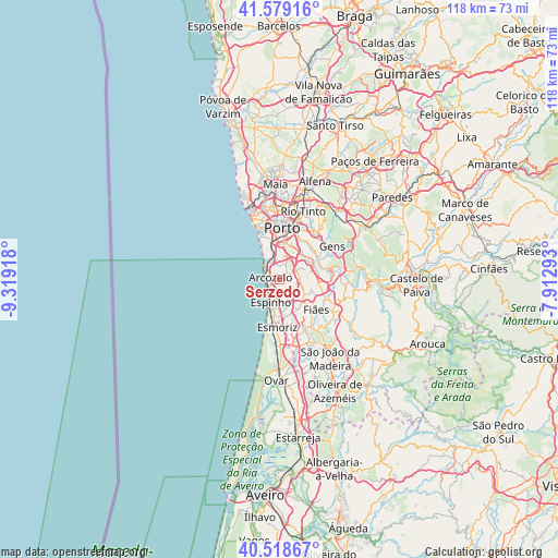
Serzedo GPS coordinates[2]
41° 3' 3.78" North, 8° 36' 57.78" West
| Map corner | latitude | longitude |
|---|---|---|
| Upper-left | 41.57916°, | -9.31918° |
| Center: | 41.05105°, | -8.61605° |
| Lower-right: | 40.51867°, | -7.91293° |
| Map W x H: | 117.9×117.9 km | = 73.3×73.3mi |
| max Lat: | 42.11337° ⇑28.2% North |
| Serzedo: | 41.05105° |
| min Lat: | ⇓71.8% South 32.6448° |
| min Long | Serzedo | max Long |
| -31.17847° | -8.61605° | -6.27308° |
| W 45.5%⇐ | ⇒54.5% E |
Elevation
Elevation of Serzedo is 89 m = 292 ft, and this is 88 m = 289 ft below average elevation for this country.
| Max E: |
1008 m = 3307 ft | 56.2% |
| Avg. | 177 m = 581 ft | |
| Serzedo | 89 m = 292 ft | |
Min E: |
-128 m = -420 ft | 43.8% |
See also: Portugal elevation on elevation.city.
Geographical zone
Serzedo is located in North temperate zone (between Tropic of Cancer and the Arctic Circle). Distance of this Northern Tropic circle is 1958.5 km =1217 mi to South.| Distance of | km | miles | from Serzedo |
|---|---|---|---|
| North Pole | 5442.6 | 3381.9 | to North |
| Arctic Circle | 2836.7 | 1762.6 | to North |
| Tropic Cancer | 1958.5 | 1217 | to South |
| Equator | 4564.4 | 2836.2 | to South |


Nearby cities:
15 places around Serzedo: (largest is in red/bold)
• Arcozelo
1.8 km =1.1 mi,  312°
312°
• Azenha
2.9 km =1.8 mi,  345°
345°
• Canelas
3.8 km =2.4 mi,  20°
20°
• Espinho
5.3 km =3.3 mi,  203°
203°
• Grijó
3.9 km =2.4 mi,  129°
129°
• Gulpilhares
3.7 km =2.3 mi, 345°
• Nogueira da Regedoura
5.5 km =3.4 mi,  158°
158°
• Olival
6 km =3.7 mi,  90°
90°
• Perozinho
3 km =1.9 mi,  58°
58°
• Sermonde
2.7 km =1.7 mi,  99°
99°
• Silvalde
6.6 km =4.1 mi,  187°
187°
• São Félix da Marinha
1.8 km =1.1 mi, 197°
• Vila Nova da Telha
3.1 km =1.9 mi,  317°
317°
• Vilar de Andorinho
6.6 km =4.1 mi, 22°
• Vilar do Paraíso
4.3 km =2.7 mi, 354°
Sources, notices
• [Note1] Compared only with cities in Portugal existing in our database
• [Src1] Map data: © OpenStreetMap contributors (CC-BY-SA)
• [Src2] Other city data from geonames.org with taken over terms of usage.
• [Src3] Geographical zone / Annual Mean Temperature by Robert A. Rohde @ Wikipedia
