Sermonde geodata
Sermonde (Porto) is a populated place; located in Portugal in Europe/Lisbon (GMT+1) time zone. With population of 1,360 people, there are 703 cities with bigger population in this country. Compared to other cities in Portugal, 71.6% of cities are located further ↓South; 52.1% of cities are located further →East and 51.1% of cities have lower elevation than Sermonde. Note1


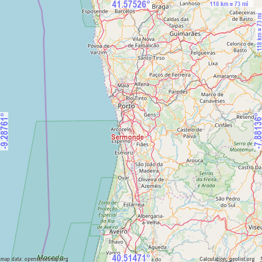
Sermonde GPS coordinates[2]
41° 2' 49.632" North, 8° 35' 4.164" West
| Map corner | latitude | longitude |
|---|---|---|
| Upper-left | 41.57526°, | -9.28761° |
| Center: | 41.04712°, | -8.58449° |
| Lower-right: | 40.51471°, | -7.88136° |
| Map W x H: | 117.9×117.9 km | = 73.3×73.3mi |
| max Lat: | 42.11337° ⇑28.4% North |
| Sermonde: | 41.04712° |
| min Lat: | ⇓71.6% South 32.6448° |
| min Long | Sermonde | max Long |
| -31.17847° | -8.58449° | -6.27308° |
| W 47.9%⇐ | ⇒52.1% E |
Elevation
Elevation of Sermonde is 117 m = 384 ft, and this is 60 m = 197 ft below average elevation for this country.
| Max E: |
1008 m = 3307 ft | 48.9% |
| Avg. | 177 m = 581 ft | |
| Sermonde | 117 m = 384 ft | |
Min E: |
-128 m = -420 ft | 51.1% |
See also: Portugal elevation on elevation.city.
Geographical zone
Sermonde is located in North temperate zone (between Tropic of Cancer and the Arctic Circle). Distance of this Northern Tropic circle is 1958.1 km =1216.7 mi to South.| Distance of | km | miles | from Sermonde |
|---|---|---|---|
| North Pole | 5443.1 | 3382.2 | to North |
| Arctic Circle | 2837.2 | 1763 | to North |
| Tropic Cancer | 1958.1 | 1216.7 | to South |
| Equator | 4564 | 2835.9 | to South |


Nearby cities:
15 places around Sermonde: (largest is in red/bold)
• Arcozelo
4.3 km =2.7 mi,  292°
292°
• Argoncilhe
4.5 km =2.8 mi,  122°
122°
• Azenha
4.7 km =2.9 mi,  314°
314°
• Canelas
4.2 km =2.6 mi,  342°
342°
• Espinho
6.5 km =4 mi,  227°
227°
• Grijó
2.1 km =1.3 mi,  170°
170°
• Gulpilhares
5.3 km =3.3 mi,  318°
318°
• Nogueira da Regedoura
4.7 km =2.9 mi,  187°
187°
• Olival
3.4 km =2.1 mi,  84°
84°
• Perozinho
2 km =1.2 mi,  358°
358°
• Serzedo
2.7 km =1.7 mi,  279°
279°
• São Félix da Marinha
3.4 km =2.1 mi,  248°
248°
• Vila Nova da Telha
5.5 km =3.4 mi,  299°
299°
• Vilar de Andorinho
6.5 km =4 mi, 358°
• Vilar do Paraíso
5.6 km =3.5 mi,  327°
327°
Sources, notices
• [Note1] Compared only with cities in Portugal existing in our database
• [Src1] Map data: © OpenStreetMap contributors (CC-BY-SA)
• [Src2] Other city data from geonames.org with taken over terms of usage.
• [Src3] Geographical zone / Annual Mean Temperature by Robert A. Rohde @ Wikipedia
