Avintes geodata
Avintes (Porto) is a populated place; located in Portugal in Europe/Lisbon (GMT+1) time zone. With population of 11,577 people, there are 180 cities with bigger population in this country. Compared to other cities in Portugal, 74.5% of cities are located further ↓South; 51.1% of cities are located further ←West and 57.2% of cities have higher elevation than Avintes. Note1


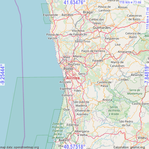
Avintes GPS coordinates[2]
41° 6' 25.596" North, 8° 33' 4.716" West
| Map corner | latitude | longitude |
|---|---|---|
| Upper-left | 41.63476°, | -9.25444° |
| Center: | 41.10711°, | -8.55131° |
| Lower-right: | 40.57518°, | -7.84819° |
| Map W x H: | 117.8×117.8 km | = 73.2×73.2mi |
| max Lat: | 42.11337° ⇑25.5% North |
| Avintes: | 41.10711° |
| min Lat: | ⇓74.5% South 32.6448° |
| min Long | Avintes | max Long |
| -31.17847° | -8.55131° | -6.27308° |
| W 51.1%⇐ | ⇒48.9% E |
Elevation
Elevation of Avintes is 86 m = 282 ft, and this is 91 m = 299 ft below average elevation for this country.
| Max E: |
1008 m = 3307 ft | 57.2% |
| Avg. | 177 m = 581 ft | |
| Avintes | 86 m = 282 ft | |
Min E: |
-128 m = -420 ft | 42.8% |
See also: Portugal elevation on elevation.city.
Geographical zone
Avintes is located in North temperate zone (between Tropic of Cancer and the Arctic Circle). Distance of this Northern Tropic circle is 1964.8 km =1220.9 mi to South.| Distance of | km | miles | from Avintes |
|---|---|---|---|
| North Pole | 5436.4 | 3378 | to North |
| Arctic Circle | 2830.5 | 1758.8 | to North |
| Tropic Cancer | 1964.8 | 1220.9 | to South |
| Equator | 4570.7 | 2840.1 | to South |


Nearby cities:
15 places around Avintes: (largest is in red/bold)
• Canelas
4.9 km =3 mi,  237°
237°
• Foz do Sousa
4.3 km =2.7 mi,  105°
105°
• Fânzeres
7 km =4.3 mi,  15°
15°
• Gondomar
4.5 km =2.8 mi, 21°
• Gulpilhares
6.9 km =4.3 mi,  246°
246°
• Jovim
2.7 km =1.7 mi,  80°
80°
• Olival
6.4 km =4 mi,  174°
174°
• Oliveira do Douro
3.4 km =2.1 mi,  304°
304°
• Perozinho
5.5 km =3.4 mi,  211°
211°
• Porto
6.9 km =4.3 mi,  313°
313°
• São Pedro da Cova
5.9 km =3.7 mi,  46°
46°
• Valbom
2.6 km =1.6 mi,  339°
339°
• Vila Nova de Gaia
5.5 km =3.4 mi,  290°
290°
• Vilar de Andorinho
2.9 km =1.8 mi,  267°
267°
• Vilar do Paraíso
6.2 km =3.9 mi, 251°
Sources, notices
• [Note1] Compared only with cities in Portugal existing in our database
• [Src1] Map data: © OpenStreetMap contributors (CC-BY-SA)
• [Src2] Other city data from geonames.org with taken over terms of usage.
• [Src3] Geographical zone / Annual Mean Temperature by Robert A. Rohde @ Wikipedia
