Valongo geodata
Valongo (Aveiro) is a populated place; located in Portugal in Europe/Lisbon (GMT+1) time zone. With population of 5,085 people, there are 414 cities with bigger population in this country. Compared to other cities in Portugal, 63.1% of cities are located further ↓South; 58.6% of cities are located further ←West and 61.8% of cities have higher elevation than Valongo. Note1


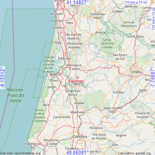
Valongo GPS coordinates[2]
40° 37' 0.012" North, 8° 27' 0" West
| Map corner | latitude | longitude |
|---|---|---|
| Upper-left | 41.14827°, | -9.15312° |
| Center: | 40.61667°, | -8.45° |
| Lower-right: | 40.08081°, | -7.74687° |
| Map W x H: | 118.7×118.7 km | = 73.8×73.8mi |
| max Lat: | 42.11337° ⇑36.9% North |
| Valongo: | 40.61667° |
| min Lat: | ⇓63.1% South 32.6448° |
| min Long | Valongo | max Long |
| -31.17847° | -8.45° | -6.27308° |
| W 58.6%⇐ | ⇒41.4% E |
Elevation
Elevation of Valongo is 73 m = 240 ft, and this is 104 m = 341 ft below average elevation for this country.
| Max E: |
1008 m = 3307 ft | 61.8% |
| Avg. | 177 m = 581 ft | |
| Valongo | 73 m = 240 ft | |
Min E: |
-128 m = -420 ft | 38.2% |
See also: Portugal elevation on elevation.city.
Geographical zone
Valongo is located in North temperate zone (between Tropic of Cancer and the Arctic Circle). Distance of this Northern Tropic circle is 1910.2 km =1186.9 mi to South.| Distance of | km | miles | from Valongo |
|---|---|---|---|
| North Pole | 5490.9 | 3411.9 | to North |
| Arctic Circle | 2885 | 1792.7 | to North |
| Tropic Cancer | 1910.2 | 1186.9 | to South |
| Equator | 4516.2 | 2806.2 | to South |


Nearby cities:
15 places around Valongo: (largest is in red/bold)
• Aguada de Cima
10.6 km =6.6 mi,  169°
169°
• Albergaria-a-Velha
8.9 km =5.5 mi,  343°
343°
• Aradas
16.2 km =10.1 mi,  271°
271°
• Aveiro
16.8 km =10.4 mi,  280°
280°
• Belazaima do Chão
11.8 km =7.3 mi,  142°
142°
• Branca
16.9 km =10.5 mi,  350°
350°
• Eixo
10.1 km =6.3 mi, 276°
• Esgueira
15.6 km =9.7 mi, 283°
• Oiã
11.1 km =6.9 mi,  222°
222°
• Oliveira do Bairro
11.9 km =7.4 mi,  198°
198°
• Oliveirinha
12 km =7.5 mi,  264°
264°
• Salreu
16.4 km =10.2 mi,  326°
326°
• Sangalhos
14.5 km =9 mi,  186°
186°
• Sever do Vouga
14.9 km =9.3 mi,  28°
28°
• Águeda
4.4 km =2.7 mi, 173°
Sources, notices
• [Note1] Compared only with cities in Portugal existing in our database
• [Src1] Map data: © OpenStreetMap contributors (CC-BY-SA)
• [Src2] Other city data from geonames.org with taken over terms of usage.
• [Src3] Geographical zone / Annual Mean Temperature by Robert A. Rohde @ Wikipedia
