Aguada de Cima geodata
Aguada de Cima (Aveiro) is a populated place; located in Portugal in Europe/Lisbon (GMT+1) time zone. With population of 4,388 people, there are 487 cities with bigger population in this country. Compared to other cities in Portugal, 61.5% of cities are located further ↓South; 60.7% of cities are located further ←West and 74.9% of cities have higher elevation than Aguada de Cima. Note1


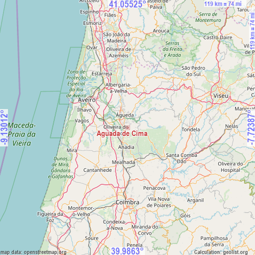
Aguada de Cima GPS coordinates[2]
40° 31' 22.476" North, 8° 25' 37.2" West
| Map corner | latitude | longitude |
|---|---|---|
| Upper-left | 41.05525°, | -9.13012° |
| Center: | 40.52291°, | -8.427° |
| Lower-right: | 39.9863°, | -7.72387° |
| Map W x H: | 118.9×118.9 km | = 73.9×73.9mi |
| max Lat: | 42.11337° ⇑38.5% North |
| Aguada de Cima: | 40.52291° |
| min Lat: | ⇓61.5% South 32.6448° |
| min Long | Aguada de Cima | max Long |
| -31.17847° | -8.427° | -6.27308° |
| W 60.7%⇐ | ⇒39.3% E |
Elevation
Elevation of Aguada de Cima is 41 m = 135 ft, and this is 136 m = 446 ft below average elevation for this country.
| Max E: |
1008 m = 3307 ft | 74.9% |
| Avg. | 177 m = 581 ft | |
| Aguada de Cima | 41 m = 135 ft | |
Min E: |
-128 m = -420 ft | 25.1% |
See also: Portugal elevation on elevation.city.
Geographical zone
Aguada de Cima is located in North temperate zone (between Tropic of Cancer and the Arctic Circle). Distance of this Northern Tropic circle is 1899.8 km =1180.5 mi to South.| Distance of | km | miles | from Aguada de Cima |
|---|---|---|---|
| North Pole | 5501.3 | 3418.3 | to North |
| Arctic Circle | 2895.4 | 1799.1 | to North |
| Tropic Cancer | 1899.8 | 1180.5 | to South |
| Equator | 4505.7 | 2799.7 | to South |


Nearby cities:
15 places around Aguada de Cima: (largest is in red/bold)
• Albergaria-a-Velha
19.5 km =12.1 mi,  346°
346°
• Anadia
9.4 km =5.8 mi,  183°
183°
• Aradas
21.2 km =13.2 mi,  300°
300°
• Arcos
8.4 km =5.2 mi,  188°
188°
• Belazaima do Chão
5.3 km =3.3 mi,  78°
78°
• Eixo
16.7 km =10.4 mi,  314°
314°
• Luso
16 km =9.9 mi,  165°
165°
• Mealhada
16.2 km =10.1 mi, 186°
• Oiã
9.7 km =6 mi,  283°
283°
• Oliveira do Bairro
5.7 km =3.5 mi,  260°
260°
• Oliveirinha
16.8 km =10.4 mi, 303°
• Pampilhosa do Botão
20.8 km =12.9 mi, 180°
• Sangalhos
5.4 km =3.4 mi,  221°
221°
• Valongo
10.6 km =6.6 mi, 349°
• Águeda
6.2 km =3.9 mi, 346°
Sources, notices
• [Note1] Compared only with cities in Portugal existing in our database
• [Src1] Map data: © OpenStreetMap contributors (CC-BY-SA)
• [Src2] Other city data from geonames.org with taken over terms of usage.
• [Src3] Geographical zone / Annual Mean Temperature by Robert A. Rohde @ Wikipedia
