Albergaria-a-Velha geodata
Albergaria-a-Velha (Aveiro) is a seat of a second-order administrative division; located in Portugal in Europe/Lisbon (GMT+1) time zone. With population of 7,974 people, there are 281 cities with bigger population in this country. Compared to other cities in Portugal, 64.6% of cities are located further ↓South; 56% of cities are located further ←West and 55% of cities have lower elevation than Albergaria-a-Velha. Note1


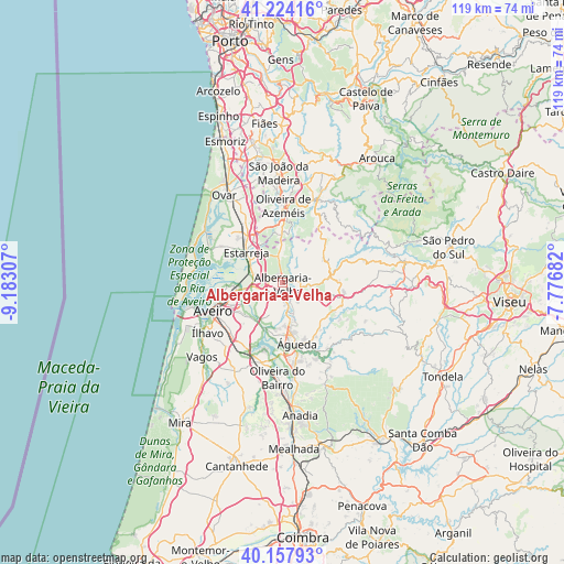
Albergaria-a-Velha GPS coordinates[2]
40° 41' 35.448" North, 8° 28' 47.784" West
| Map corner | latitude | longitude |
|---|---|---|
| Upper-left | 41.22416°, | -9.18307° |
| Center: | 40.69318°, | -8.47994° |
| Lower-right: | 40.15793°, | -7.77682° |
| Map W x H: | 118.6×118.6 km | = 73.7×73.7mi |
| max Lat: | 42.11337° ⇑35.4% North |
| Albergaria-a-Velha: | 40.69318° |
| min Lat: | ⇓64.6% South 32.6448° |
| min Long | Albergaria-a-Ve | max Long |
| -31.17847° | -8.47994° | -6.27308° |
| W 56%⇐ | ⇒44% E |
Elevation
Elevation of Albergaria-a-Velha is 128 m = 420 ft, and this is 49 m = 161 ft below average elevation for this country.
| Max E: |
1008 m = 3307 ft | 45% |
| Avg. | 177 m = 581 ft | |
| Albergaria-a-Velha | 128 m = 420 ft | |
Min E: |
-128 m = -420 ft | 55% |
See also: Portugal elevation on elevation.city.
Geographical zone
Albergaria-a-Velha is located in North temperate zone (between Tropic of Cancer and the Arctic Circle). Distance of this Northern Tropic circle is 1918.7 km =1192.2 mi to South.| Distance of | km | miles | from Albergaria-a-Velha |
|---|---|---|---|
| North Pole | 5482.4 | 3406.6 | to North |
| Arctic Circle | 2876.5 | 1787.4 | to North |
| Tropic Cancer | 1918.7 | 1192.2 | to South |
| Equator | 4524.7 | 2811.5 | to South |


Nearby cities:
15 places around Albergaria-a-Velha: (largest is in red/bold)
• Aradas
15.9 km =9.9 mi,  239°
239°
• Avanca
14.9 km =9.3 mi,  328°
328°
• Aveiro
15 km =9.3 mi,  248°
248°
• Beduido
10.5 km =6.5 mi,  319°
319°
• Branca
8.2 km =5.1 mi,  358°
358°
• Eixo
10.5 km =6.5 mi,  225°
225°
• Esgueira
13.5 km =8.4 mi, 248°
• Estarreja
10.5 km =6.5 mi,  312°
312°
• Murtosa
14.2 km =8.8 mi,  290°
290°
• Oliveira de Azemeis
16.4 km =10.2 mi,  1°
1°
• Oliveirinha
13.4 km =8.3 mi,  224°
224°
• Salreu
8.3 km =5.2 mi, 308°
• Sever do Vouga
10.6 km =6.6 mi,  64°
64°
• Valongo
8.9 km =5.5 mi,  163°
163°
• Águeda
13.2 km =8.2 mi,  166°
166°
Sources, notices
• [Note1] Compared only with cities in Portugal existing in our database
• [Src1] Map data: © OpenStreetMap contributors (CC-BY-SA)
• [Src2] Other city data from geonames.org with taken over terms of usage.
• [Src3] Geographical zone / Annual Mean Temperature by Robert A. Rohde @ Wikipedia
