Eixo geodata
Eixo (Aveiro) is a populated place; located in Portugal in Europe/Lisbon (GMT+1) time zone. With population of 5,978 people, there are 363 cities with bigger population in this country. Compared to other cities in Portugal, 63.5% of cities are located further ↓South; 50.5% of cities are located further →East and 88.3% of cities have higher elevation than Eixo. Note1


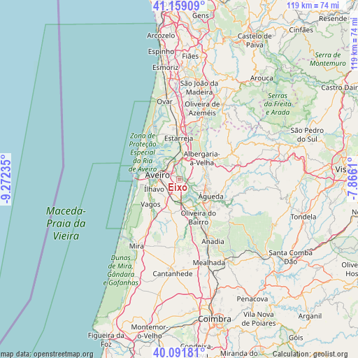
Eixo GPS coordinates[2]
40° 37' 39.288" North, 8° 34' 9.192" West
| Map corner | latitude | longitude |
|---|---|---|
| Upper-left | 41.15909°, | -9.27235° |
| Center: | 40.62758°, | -8.56922° |
| Lower-right: | 40.09181°, | -7.8661° |
| Map W x H: | 118.7×118.7 km | = 73.8×73.8mi |
| max Lat: | 42.11337° ⇑36.5% North |
| Eixo: | 40.62758° |
| min Lat: | ⇓63.5% South 32.6448° |
| min Long | Eixo | max Long |
| -31.17847° | -8.56922° | -6.27308° |
| W 49.5%⇐ | ⇒50.5% E |
Elevation
Elevation of Eixo is 19 m = 62 ft, and this is 158 m = 518 ft below average elevation for this country.
| Max E: |
1008 m = 3307 ft | 88.3% |
| Avg. | 177 m = 581 ft | |
| Eixo | 19 m = 62 ft | |
Min E: |
-128 m = -420 ft | 11.7% |
See also: Portugal elevation on elevation.city.
Geographical zone
Eixo is located in North temperate zone (between Tropic of Cancer and the Arctic Circle). Distance of this Northern Tropic circle is 1911.4 km =1187.7 mi to South.| Distance of | km | miles | from Eixo |
|---|---|---|---|
| North Pole | 5489.7 | 3411.1 | to North |
| Arctic Circle | 2883.8 | 1791.9 | to North |
| Tropic Cancer | 1911.4 | 1187.7 | to South |
| Equator | 4517.4 | 2807 | to South |


Nearby cities:
15 places around Eixo: (largest is in red/bold)
• Albergaria-a-Velha
10.5 km =6.5 mi,  45°
45°
• Aradas
6.2 km =3.9 mi,  263°
263°
• Aveiro
6.7 km =4.2 mi,  286°
286°
• Esgueira
5.6 km =3.5 mi,  295°
295°
• Gafanha da Encarnação
13.9 km =8.6 mi,  265°
265°
• Gafanha da Nazaré
12.2 km =7.6 mi, 274°
• Murtosa
13.5 km =8.4 mi,  334°
334°
• Oiã
9.8 km =6.1 mi,  164°
164°
• Oliveira do Bairro
14.1 km =8.8 mi,  153°
153°
• Oliveirinha
3 km =1.9 mi,  220°
220°
• Salreu
12.5 km =7.8 mi,  4°
4°
• Vagos
12.4 km =7.7 mi,  230°
230°
• Valongo
10.1 km =6.3 mi,  96°
96°
• Águeda
11.9 km =7.4 mi,  117°
117°
• Ílhavo
9 km =5.6 mi,  251°
251°
Sources, notices
• [Note1] Compared only with cities in Portugal existing in our database
• [Src1] Map data: © OpenStreetMap contributors (CC-BY-SA)
• [Src2] Other city data from geonames.org with taken over terms of usage.
• [Src3] Geographical zone / Annual Mean Temperature by Robert A. Rohde @ Wikipedia
