São Jacinto geodata
São Jacinto (Aveiro) is a populated place; located in Portugal in Europe/Lisbon (GMT+1) time zone. With population of 993 people, there are 752 cities with bigger population in this country. Compared to other cities in Portugal, 64.3% of cities are located further ↓South; 64.5% of cities are located further →East and 98.5% of cities have higher elevation than São Jacinto. Note1


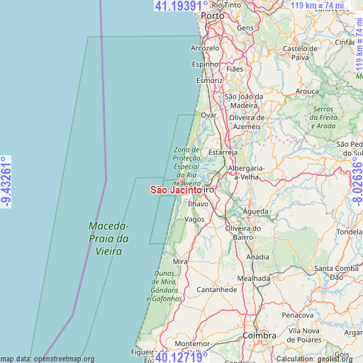
São Jacinto GPS coordinates[2]
40° 39' 45.648" North, 8° 43' 46.128" West
| Map corner | latitude | longitude |
|---|---|---|
| Upper-left | 41.19391°, | -9.43261° |
| Center: | 40.66268°, | -8.72948° |
| Lower-right: | 40.12719°, | -8.02636° |
| Map W x H: | 118.6×118.6 km | = 73.7×73.7mi |
| max Lat: | 42.11337° ⇑35.7% North |
| São Jacinto: | 40.66268° |
| min Lat: | ⇓64.3% South 32.6448° |
| min Long | São Jacinto | max Long |
| -31.17847° | -8.72948° | -6.27308° |
| W 35.5%⇐ | ⇒64.5% E |
Elevation
Elevation of São Jacinto is 3 m = 10 ft, and this is 174 m = 571 ft below average elevation for this country.
| Max E: |
1008 m = 3307 ft | 98.5% |
| Avg. | 177 m = 581 ft | |
| São Jacinto | 3 m = 10 ft | |
Min E: |
-128 m = -420 ft | 1.5% |
See also: Portugal elevation on elevation.city.
Geographical zone
São Jacinto is located in North temperate zone (between Tropic of Cancer and the Arctic Circle). Distance of this Northern Tropic circle is 1915.3 km =1190.1 mi to South.| Distance of | km | miles | from São Jacinto |
|---|---|---|---|
| North Pole | 5485.8 | 3408.7 | to North |
| Arctic Circle | 2879.9 | 1789.5 | to North |
| Tropic Cancer | 1915.3 | 1190.1 | to South |
| Equator | 4521.3 | 2809.4 | to South |


Nearby cities:
15 places around São Jacinto: (largest is in red/bold)
• Aradas
8.7 km =5.4 mi,  122°
122°
• Avanca
20.9 km =13 mi,  39°
39°
• Aveiro
7.4 km =4.6 mi,  106°
106°
• Beduido
18.1 km =11.2 mi,  51°
51°
• Eixo
14.1 km =8.8 mi, 106°
• Esgueira
8.6 km =5.3 mi,  100°
100°
• Estarreja
16.9 km =10.5 mi, 51°
• Gafanha da Encarnação
5 km =3.1 mi,  183°
183°
• Gafanha da Nazaré
3.2 km =2 mi,  155°
155°
• Murtosa
11.3 km =7 mi, 43°
• Oliveirinha
13.1 km =8.1 mi, 118°
• Pardilhó
17.5 km =10.9 mi,  29°
29°
• Salreu
16.9 km =10.5 mi,  59°
59°
• Vagos
12.5 km =7.8 mi, 161°
• Ílhavo
8.4 km =5.2 mi,  143°
143°
Sources, notices
• [Note1] Compared only with cities in Portugal existing in our database
• [Src1] Map data: © OpenStreetMap contributors (CC-BY-SA)
• [Src2] Other city data from geonames.org with taken over terms of usage.
• [Src3] Geographical zone / Annual Mean Temperature by Robert A. Rohde @ Wikipedia
