Vagos geodata
Vagos (Aveiro) is a seat of a second-order administrative division; located in Portugal in Europe/Lisbon (GMT+1) time zone. With population of 4,529 people, there are 467 cities with bigger population in this country. Compared to other cities in Portugal, 62.2% of cities are located further ↓South; 61.7% of cities are located further →East and 87.7% of cities have higher elevation than Vagos. Note1


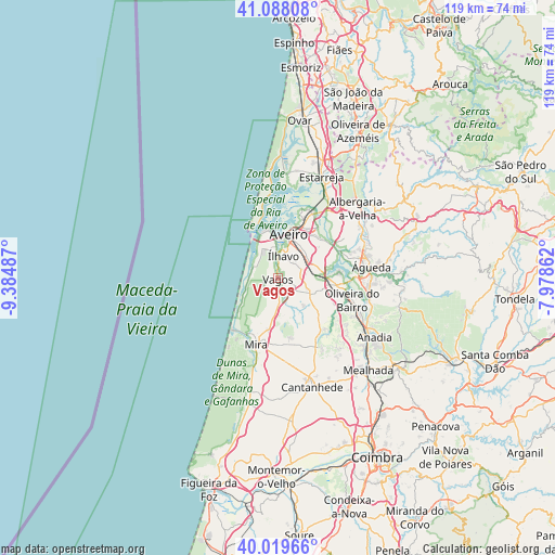
Vagos GPS coordinates[2]
40° 33' 21.6" North, 8° 40' 54.3" West
| Map corner | latitude | longitude |
|---|---|---|
| Upper-left | 41.08808°, | -9.38487° |
| Center: | 40.556°, | -8.68175° |
| Lower-right: | 40.01966°, | -7.97862° |
| Map W x H: | 118.8×118.8 km | = 73.8×73.8mi |
| max Lat: | 42.11337° ⇑37.8% North |
| Vagos: | 40.556° |
| min Lat: | ⇓62.2% South 32.6448° |
| min Long | Vagos | max Long |
| -31.17847° | -8.68175° | -6.27308° |
| W 38.3%⇐ | ⇒61.7% E |
Elevation
Elevation of Vagos is 20 m = 66 ft, and this is 157 m = 515 ft below average elevation for this country.
| Max E: |
1008 m = 3307 ft | 87.7% |
| Avg. | 177 m = 581 ft | |
| Vagos | 20 m = 66 ft | |
Min E: |
-128 m = -420 ft | 12.3% |
See also: Portugal elevation on elevation.city.
Geographical zone
Vagos is located in North temperate zone (between Tropic of Cancer and the Arctic Circle). Distance of this Northern Tropic circle is 1903.5 km =1182.8 mi to South.| Distance of | km | miles | from Vagos |
|---|---|---|---|
| North Pole | 5497.7 | 3416.1 | to North |
| Arctic Circle | 2891.8 | 1796.9 | to North |
| Tropic Cancer | 1903.5 | 1182.8 | to South |
| Equator | 4509.4 | 2802 | to South |


Nearby cities:
15 places around Vagos: (largest is in red/bold)
• Aradas
8 km =5 mi,  24°
24°
• Aveiro
10.3 km =6.4 mi, 17°
• Eixo
12.4 km =7.7 mi,  50°
50°
• Esgueira
11.2 km =7 mi, 23°
• Gafanha da Encarnação
8.1 km =5 mi,  327°
327°
• Gafanha da Nazaré
9.3 km =5.8 mi,  343°
343°
• Mira
14.9 km =9.3 mi,  198°
198°
• Murtosa
20.5 km =12.7 mi,  10°
10°
• Oiã
12.2 km =7.6 mi,  97°
97°
• Oliveira do Bairro
16.5 km =10.3 mi,  106°
106°
• Oliveirinha
9.5 km =5.9 mi, 53°
• Sangalhos
19.5 km =12.1 mi, 113°
• São Jacinto
12.5 km =7.8 mi, 341°
• Águeda
20.2 km =12.6 mi,  83°
83°
• Ílhavo
5.2 km =3.2 mi, 10°
Sources, notices
• [Note1] Compared only with cities in Portugal existing in our database
• [Src1] Map data: © OpenStreetMap contributors (CC-BY-SA)
• [Src2] Other city data from geonames.org with taken over terms of usage.
• [Src3] Geographical zone / Annual Mean Temperature by Robert A. Rohde @ Wikipedia
