Beduido geodata
Beduido (Aveiro) is a populated place; located in Portugal in Europe/Lisbon (GMT+1) time zone. With population of 8,201 people, there are 275 cities with bigger population in this country. Compared to other cities in Portugal, 65.7% of cities are located further ↓South; 50.1% of cities are located further ←West and 79.8% of cities have higher elevation than Beduido. Note1


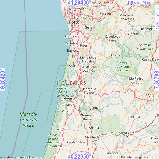
Beduido GPS coordinates[2]
40° 45' 51.372" North, 8° 33' 39.96" West
| Map corner | latitude | longitude |
|---|---|---|
| Upper-left | 41.29468°, | -9.26423° |
| Center: | 40.76427°, | -8.5611° |
| Lower-right: | 40.22959°, | -7.85798° |
| Map W x H: | 118.4×118.4 km | = 73.6×73.6mi |
| max Lat: | 42.11337° ⇑34.3% North |
| Beduido: | 40.76427° |
| min Lat: | ⇓65.7% South 32.6448° |
| min Long | Beduido | max Long |
| -31.17847° | -8.5611° | -6.27308° |
| W 50.1%⇐ | ⇒49.9% E |
Elevation
Elevation of Beduido is 33 m = 108 ft, and this is 144 m = 472 ft below average elevation for this country.
| Max E: |
1008 m = 3307 ft | 79.8% |
| Avg. | 177 m = 581 ft | |
| Beduido | 33 m = 108 ft | |
Min E: |
-128 m = -420 ft | 20.2% |
See also: Portugal elevation on elevation.city.
Geographical zone
Beduido is located in North temperate zone (between Tropic of Cancer and the Arctic Circle). Distance of this Northern Tropic circle is 1926.6 km =1197.1 mi to South.| Distance of | km | miles | from Beduido |
|---|---|---|---|
| North Pole | 5474.5 | 3401.7 | to North |
| Arctic Circle | 2868.6 | 1782.5 | to North |
| Tropic Cancer | 1926.6 | 1197.1 | to South |
| Equator | 4532.6 | 2816.4 | to South |


Nearby cities:
15 places around Beduido: (largest is in red/bold)
• Albergaria-a-Velha
10.5 km =6.5 mi,  139°
139°
• Avanca
4.9 km =3 mi,  349°
349°
• Branca
6.6 km =4.1 mi,  87°
87°
• Cucujães
13 km =8.1 mi,  20°
20°
• Esgueira
14.1 km =8.8 mi,  204°
204°
• Estarreja
1.3 km =0.8 mi,  226°
226°
• Murtosa
7.1 km =4.4 mi,  244°
244°
• Oliveira de Azemeis
11.2 km =7 mi,  40°
40°
• Ovar
11.8 km =7.3 mi,  332°
332°
• Pardilhó
6.7 km =4.2 mi,  305°
305°
• Salreu
2.8 km =1.7 mi,  173°
173°
• São João
12.2 km =7.6 mi,  341°
341°
• São Roque
14.2 km =8.8 mi,  32°
32°
• Vila Chã
13.9 km =8.6 mi, 34°
• Válega
8.2 km =5.1 mi, 348°
Sources, notices
• [Note1] Compared only with cities in Portugal existing in our database
• [Src1] Map data: © OpenStreetMap contributors (CC-BY-SA)
• [Src2] Other city data from geonames.org with taken over terms of usage.
• [Src3] Geographical zone / Annual Mean Temperature by Robert A. Rohde @ Wikipedia
