Murtosa geodata
Murtosa (Aveiro) is a seat of a second-order administrative division; located in Portugal in Europe/Lisbon (GMT+1) time zone. With population of 8,282 people, there are 272 cities with bigger population in this country. Compared to other cities in Portugal, 65.2% of cities are located further ↓South; 57.6% of cities are located further →East and 96.7% of cities have higher elevation than Murtosa. Note1


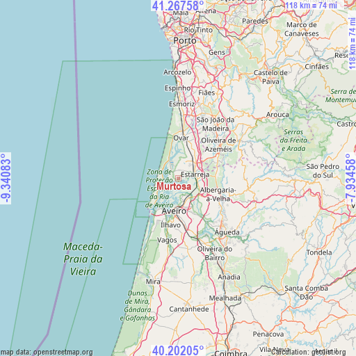
Murtosa GPS coordinates[2]
40° 44' 13.02" North, 8° 38' 15.72" West
| Map corner | latitude | longitude |
|---|---|---|
| Upper-left | 41.26758°, | -9.34083° |
| Center: | 40.73695°, | -8.6377° |
| Lower-right: | 40.20205°, | -7.93458° |
| Map W x H: | 118.5×118.5 km | = 73.6×73.6mi |
| max Lat: | 42.11337° ⇑34.8% North |
| Murtosa: | 40.73695° |
| min Lat: | ⇓65.2% South 32.6448° |
| min Long | Murtosa | max Long |
| -31.17847° | -8.6377° | -6.27308° |
| W 42.4%⇐ | ⇒57.6% E |
Elevation
Elevation of Murtosa is 8 m = 26 ft, and this is 169 m = 554 ft below average elevation for this country.
| Max E: |
1008 m = 3307 ft | 96.7% |
| Avg. | 177 m = 581 ft | |
| Murtosa | 8 m = 26 ft | |
Min E: |
-128 m = -420 ft | 3.3% |
See also: Portugal elevation on elevation.city.
Geographical zone
Murtosa is located in North temperate zone (between Tropic of Cancer and the Arctic Circle). Distance of this Northern Tropic circle is 1923.6 km =1195.3 mi to South.| Distance of | km | miles | from Murtosa |
|---|---|---|---|
| North Pole | 5477.5 | 3403.6 | to North |
| Arctic Circle | 2871.6 | 1784.3 | to North |
| Tropic Cancer | 1923.6 | 1195.3 | to South |
| Equator | 4529.5 | 2814.5 | to South |


Nearby cities:
15 places around Murtosa: (largest is in red/bold)
• Albergaria-a-Velha
14.2 km =8.8 mi,  110°
110°
• Aradas
12.9 km =8 mi,  181°
181°
• Avanca
9.6 km =6 mi,  35°
35°
• Aveiro
10.3 km =6.4 mi, 183°
• Beduido
7.1 km =4.4 mi,  64°
64°
• Branca
13.5 km =8.4 mi,  75°
75°
• Eixo
13.5 km =8.4 mi,  154°
154°
• Esgueira
9.8 km =6.1 mi, 175°
• Estarreja
5.9 km =3.7 mi,  68°
68°
• Gafanha da Nazaré
12.9 km =8 mi,  209°
209°
• Ovar
13.6 km =8.5 mi,  4°
4°
• Pardilhó
7 km =4.3 mi,  8°
8°
• Salreu
6.8 km =4.2 mi,  87°
87°
• São Jacinto
11.3 km =7 mi,  223°
223°
• Válega
12 km =7.5 mi,  23°
23°
Sources, notices
• [Note1] Compared only with cities in Portugal existing in our database
• [Src1] Map data: © OpenStreetMap contributors (CC-BY-SA)
• [Src2] Other city data from geonames.org with taken over terms of usage.
• [Src3] Geographical zone / Annual Mean Temperature by Robert A. Rohde @ Wikipedia
