Paredes geodata
Paredes (Porto) is a seat of a second-order administrative division; located in Portugal in Europe/Lisbon (GMT+1) time zone. With population of 19,834 people, there are 98 cities with bigger population in this country. Compared to other cities in Portugal, 79.1% of cities are located further ↓South; 67.4% of cities are located further ←West and 65.2% of cities have lower elevation than Paredes. Note1


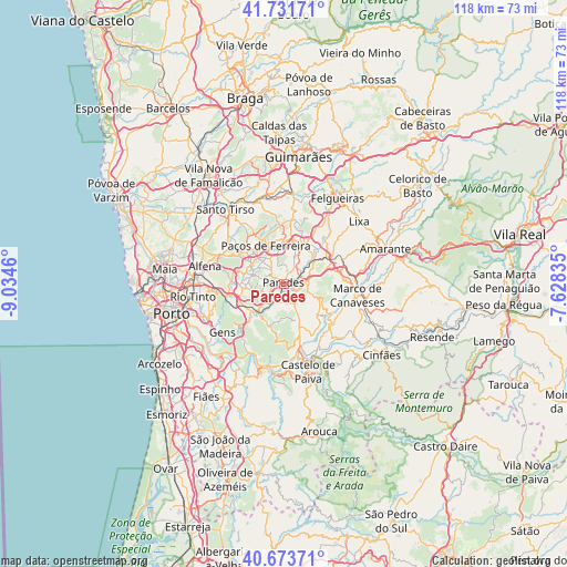
Paredes GPS coordinates[2]
41° 12' 17.46" North, 8° 19' 53.292" West
| Map corner | latitude | longitude |
|---|---|---|
| Upper-left | 41.73171°, | -9.0346° |
| Center: | 41.20485°, | -8.33147° |
| Lower-right: | 40.67371°, | -7.62835° |
| Map W x H: | 117.6×117.6 km | = 73.1×73.1mi |
| max Lat: | 42.11337° ⇑20.9% North |
| Paredes: | 41.20485° |
| min Lat: | ⇓79.1% South 32.6448° |
| min Long | Paredes | max Long |
| -31.17847° | -8.33147° | -6.27308° |
| W 67.4%⇐ | ⇒32.6% E |
Elevation
Elevation of Paredes is 179 m = 587 ft, and this is 2 m = 7 ft above average elevation for this country.
| Max E: |
1008 m = 3307 ft | 34.8% |
| Paredes | 179 m 587 ft | |
| Avg. | 177 m = 581 ft | |
Min E: |
-128 m = -420 ft | 65.2% |
See also: Portugal elevation on elevation.city.
Geographical zone
Paredes is located in North temperate zone (between Tropic of Cancer and the Arctic Circle). Distance of this Northern Tropic circle is 1975.6 km =1227.6 mi to South.| Distance of | km | miles | from Paredes |
|---|---|---|---|
| North Pole | 5425.5 | 3371.2 | to North |
| Arctic Circle | 2819.6 | 1752 | to North |
| Tropic Cancer | 1975.6 | 1227.6 | to South |
| Equator | 4581.5 | 2846.8 | to South |


Nearby cities:
15 places around Paredes: (largest is in red/bold)
• Baltar
4.9 km =3 mi,  253°
253°
• Castelões de Cepeda
0.4 km =0.2 mi,  231°
231°
• Ferreira
7 km =4.3 mi,  351°
351°
• Frazão
8.3 km =5.2 mi,  316°
316°
• Freamunde
9.3 km =5.8 mi,  358°
358°
• Gandra
8.6 km =5.3 mi,  267°
267°
• Lordelo
6.8 km =4.2 mi,  298°
298°
• Lousada
9.2 km =5.7 mi,  27°
27°
• Madalena
1.3 km =0.8 mi, 348°
• Meinedo
7.8 km =4.8 mi,  51°
51°
• Paços de Ferreira
8.8 km =5.5 mi,  334°
334°
• Penafiel
4.1 km =2.5 mi,  84°
84°
• Perafita
6.9 km =4.3 mi,  111°
111°
• Rebordosa
6.6 km =4.1 mi,  288°
288°
• Recarei
8.8 km =5.5 mi, 229°
Sources, notices
• [Note1] Compared only with cities in Portugal existing in our database
• [Src1] Map data: © OpenStreetMap contributors (CC-BY-SA)
• [Src2] Other city data from geonames.org with taken over terms of usage.
• [Src3] Geographical zone / Annual Mean Temperature by Robert A. Rohde @ Wikipedia
