Recarei geodata
Recarei (Porto) is a populated place; located in Portugal in Europe/Lisbon (GMT+1) time zone. With population of 4,856 people, there are 442 cities with bigger population in this country. Compared to other cities in Portugal, 76.2% of cities are located further ↓South; 61.8% of cities are located further ←West and 57.8% of cities have higher elevation than Recarei. Note1


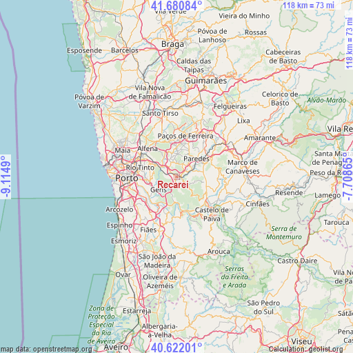
Recarei GPS coordinates[2]
41° 9' 12.816" North, 8° 24' 42.408" West
| Map corner | latitude | longitude |
|---|---|---|
| Upper-left | 41.68084°, | -9.1149° |
| Center: | 41.15356°, | -8.41178° |
| Lower-right: | 40.62201°, | -7.70865° |
| Map W x H: | 117.7×117.7 km | = 73.1×73.1mi |
| max Lat: | 42.11337° ⇑23.8% North |
| Recarei: | 41.15356° |
| min Lat: | ⇓76.2% South 32.6448° |
| min Long | Recarei | max Long |
| -31.17847° | -8.41178° | -6.27308° |
| W 61.8%⇐ | ⇒38.2% E |
Elevation
Elevation of Recarei is 85 m = 279 ft, and this is 92 m = 302 ft below average elevation for this country.
| Max E: |
1008 m = 3307 ft | 57.8% |
| Avg. | 177 m = 581 ft | |
| Recarei | 85 m = 279 ft | |
Min E: |
-128 m = -420 ft | 42.2% |
See also: Portugal elevation on elevation.city.
Geographical zone
Recarei is located in North temperate zone (between Tropic of Cancer and the Arctic Circle). Distance of this Northern Tropic circle is 1969.9 km =1224 mi to South.| Distance of | km | miles | from Recarei |
|---|---|---|---|
| North Pole | 5431.2 | 3374.8 | to North |
| Arctic Circle | 2825.3 | 1755.6 | to North |
| Tropic Cancer | 1969.9 | 1224 | to South |
| Equator | 4575.8 | 2843.3 | to South |


Nearby cities:
15 places around Recarei: (largest is in red/bold)
• Baltar
4.8 km =3 mi,  24°
24°
• Campo
5.7 km =3.5 mi,  308°
308°
• Castelões de Cepeda
8.4 km =5.2 mi,  49°
49°
• Foz do Sousa
9.8 km =6.1 mi,  230°
230°
• Fânzeres
10 km =6.2 mi,  278°
278°
• Gandra
5.6 km =3.5 mi,  340°
340°
• Gondomar
10.1 km =6.3 mi,  264°
264°
• Lordelo
9 km =5.6 mi,  4°
4°
• Madalena
9.5 km =5.9 mi,  42°
42°
• Melres
9.3 km =5.8 mi,  174°
174°
• Paredes
8.8 km =5.5 mi, 49°
• Rebordosa
7.8 km =4.8 mi, 3°
• Sobrado
7.3 km =4.5 mi,  330°
330°
• São Pedro da Cova
7.5 km =4.7 mi, 261°
• Valongo
8.3 km =5.2 mi,  298°
298°
Sources, notices
• [Note1] Compared only with cities in Portugal existing in our database
• [Src1] Map data: © OpenStreetMap contributors (CC-BY-SA)
• [Src2] Other city data from geonames.org with taken over terms of usage.
• [Src3] Geographical zone / Annual Mean Temperature by Robert A. Rohde @ Wikipedia
