Meinedo geodata
Meinedo (Porto) is a populated place; located in Portugal in Europe/Lisbon (GMT+1) time zone. With population of 4,416 people, there are 481 cities with bigger population in this country. Compared to other cities in Portugal, 81.3% of cities are located further ↓South; 70.7% of cities are located further ←West and 73% of cities have lower elevation than Meinedo. Note1


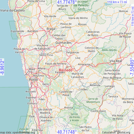
Meinedo GPS coordinates[2]
41° 14' 53.772" North, 8° 15' 29.052" West
| Map corner | latitude | longitude |
|---|---|---|
| Upper-left | 41.77478°, | -8.9612° |
| Center: | 41.24827°, | -8.25807° |
| Lower-right: | 40.71748°, | -7.55495° |
| Map W x H: | 117.6×117.6 km | = 73.1×73.1mi |
| max Lat: | 42.11337° ⇑18.7% North |
| Meinedo: | 41.24827° |
| min Lat: | ⇓81.3% South 32.6448° |
| min Long | Meinedo | max Long |
| -31.17847° | -8.25807° | -6.27308° |
| W 70.7%⇐ | ⇒29.3% E |
Elevation
Elevation of Meinedo is 219 m = 719 ft, and this is 42 m = 138 ft above average elevation for this country.
| Max E: |
1008 m = 3307 ft | 27% |
| Meinedo | 219 m 719 ft | |
| Avg. | 177 m = 581 ft | |
Min E: |
-128 m = -420 ft | 73% |
See also: Portugal elevation on elevation.city.
Geographical zone
Meinedo is located in North temperate zone (between Tropic of Cancer and the Arctic Circle). Distance of this Northern Tropic circle is 1980.5 km =1230.6 mi to South.| Distance of | km | miles | from Meinedo |
|---|---|---|---|
| North Pole | 5420.7 | 3368.3 | to North |
| Arctic Circle | 2814.8 | 1749 | to North |
| Tropic Cancer | 1980.5 | 1230.6 | to South |
| Equator | 4586.4 | 2849.9 | to South |


Nearby cities:
15 places around Meinedo: (largest is in red/bold)
• Carvalhosa
10.4 km =6.5 mi,  304°
304°
• Castelões de Cepeda
8.2 km =5.1 mi,  231°
231°
• Ferreira
7.5 km =4.7 mi,  286°
286°
• Figueiró
9.4 km =5.8 mi,  53°
53°
• Freamunde
7.8 km =4.8 mi, 304°
• Lousada
3.8 km =2.4 mi,  331°
331°
• Lustosa
11.4 km =7.1 mi, 334°
• Madalena
7.3 km =4.5 mi,  240°
240°
• Marco de Canavezes
11.6 km =7.2 mi,  128°
128°
• Paredes
7.8 km =4.8 mi, 231°
• Paços de Ferreira
10.4 km =6.5 mi, 287°
• Penafiel
4.9 km =3 mi,  205°
205°
• Perafita
7.3 km =4.5 mi,  177°
177°
• Santo Izidoro
10.5 km =6.5 mi,  113°
113°
• Vila Meã
6.2 km =3.9 mi,  87°
87°
Sources, notices
• [Note1] Compared only with cities in Portugal existing in our database
• [Src1] Map data: © OpenStreetMap contributors (CC-BY-SA)
• [Src2] Other city data from geonames.org with taken over terms of usage.
• [Src3] Geographical zone / Annual Mean Temperature by Robert A. Rohde @ Wikipedia
