Lousada geodata
Lousada (Porto) is a seat of a second-order administrative division; located in Portugal in Europe/Lisbon (GMT+1) time zone. With population of 2,166 people, there are 632 cities with bigger population in this country. Compared to other cities in Portugal, 82.9% of cities are located further ↓South; 69.9% of cities are located further ←West and 79.5% of cities have lower elevation than Lousada. Note1


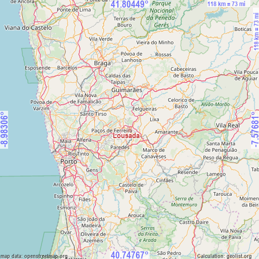
Lousada GPS coordinates[2]
41° 16' 41.592" North, 8° 16' 47.748" West
| Map corner | latitude | longitude |
|---|---|---|
| Upper-left | 41.80449°, | -8.98306° |
| Center: | 41.27822°, | -8.27993° |
| Lower-right: | 40.74767°, | -7.57681° |
| Map W x H: | 117.5×117.5 km | = 73×73mi |
| max Lat: | 42.11337° ⇑17.1% North |
| Lousada: | 41.27822° |
| min Lat: | ⇓82.9% South 32.6448° |
| min Long | Lousada | max Long |
| -31.17847° | -8.27993° | -6.27308° |
| W 69.9%⇐ | ⇒30.1% E |
Elevation
Elevation of Lousada is 283 m = 928 ft, and this is 106 m = 348 ft above average elevation for this country.
| Max E: |
1008 m = 3307 ft | 20.5% |
| Lousada | 283 m 928 ft | |
| Avg. | 177 m = 581 ft | |
Min E: |
-128 m = -420 ft | 79.5% |
See also: Portugal elevation on elevation.city.
Geographical zone
Lousada is located in North temperate zone (between Tropic of Cancer and the Arctic Circle). Distance of this Northern Tropic circle is 1983.8 km =1232.7 mi to South.| Distance of | km | miles | from Lousada |
|---|---|---|---|
| North Pole | 5417.4 | 3366.2 | to North |
| Arctic Circle | 2811.5 | 1747 | to North |
| Tropic Cancer | 1983.8 | 1232.7 | to South |
| Equator | 4589.7 | 2851.9 | to South |


Nearby cities:
15 places around Lousada: (largest is in red/bold)
• Barrosas
8.7 km =5.4 mi,  349°
349°
• Carvalhosa
7.2 km =4.5 mi,  290°
290°
• Castelões de Cepeda
9.6 km =6 mi,  208°
208°
• Ferreira
5.5 km =3.4 mi,  257°
257°
• Figueiró
9.7 km =6 mi,  76°
76°
• Frazão
10.3 km =6.4 mi, 257°
• Freamunde
4.8 km =3 mi,  283°
283°
• Lustosa
7.6 km =4.7 mi,  335°
335°
• Madalena
8.3 km =5.2 mi, 213°
• Meinedo
3.8 km =2.4 mi,  151°
151°
• Paredes
9.2 km =5.7 mi, 207°
• Paços de Ferreira
8 km =5 mi,  268°
268°
• Penafiel
7.8 km =4.8 mi,  181°
181°
• Vila Meã
8.6 km =5.3 mi,  110°
110°
• Vilarinho
10 km =6.2 mi,  334°
334°
Sources, notices
• [Note1] Compared only with cities in Portugal existing in our database
• [Src1] Map data: © OpenStreetMap contributors (CC-BY-SA)
• [Src2] Other city data from geonames.org with taken over terms of usage.
• [Src3] Geographical zone / Annual Mean Temperature by Robert A. Rohde @ Wikipedia
