Gandra geodata
Gandra (Porto) is a populated place; located in Portugal in Europe/Lisbon (GMT+1) time zone. With population of 6,034 people, there are 359 cities with bigger population in this country. Compared to other cities in Portugal, 78.8% of cities are located further ↓South; 60.2% of cities are located further ←West and 64.9% of cities have lower elevation than Gandra. Note1


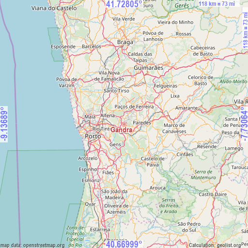
Gandra GPS coordinates[2]
41° 12' 4.176" North, 8° 26' 1.536" West
| Map corner | latitude | longitude |
|---|---|---|
| Upper-left | 41.72805°, | -9.13689° |
| Center: | 41.20116°, | -8.43376° |
| Lower-right: | 40.66999°, | -7.73064° |
| Map W x H: | 117.6×117.6 km | = 73.1×73.1mi |
| max Lat: | 42.11337° ⇑21.2% North |
| Gandra: | 41.20116° |
| min Lat: | ⇓78.8% South 32.6448° |
| min Long | Gandra | max Long |
| -31.17847° | -8.43376° | -6.27308° |
| W 60.2%⇐ | ⇒39.8% E |
Elevation
Elevation of Gandra is 177 m = 581 ft, and this is 0 m = 0 ft above average elevation for this country.
| Max E: |
1008 m = 3307 ft | 35.1% |
| Gandra | 177 m 581 ft | |
| Avg. | 177 m = 581 ft | |
Min E: |
-128 m = -420 ft | 64.9% |
See also: Portugal elevation on elevation.city.
Geographical zone
Gandra is located in North temperate zone (between Tropic of Cancer and the Arctic Circle). Distance of this Northern Tropic circle is 1975.2 km =1227.3 mi to South.| Distance of | km | miles | from Gandra |
|---|---|---|---|
| North Pole | 5425.9 | 3371.5 | to North |
| Arctic Circle | 2820 | 1752.3 | to North |
| Tropic Cancer | 1975.2 | 1227.3 | to South |
| Equator | 4581.1 | 2846.6 | to South |


Nearby cities:
15 places around Gandra: (largest is in red/bold)
• Alfena
8.6 km =5.3 mi,  297°
297°
• Baltar
4 km =2.5 mi,  103°
103°
• Campo
3.2 km =2 mi,  235°
235°
• Castelões de Cepeda
8.3 km =5.2 mi,  88°
88°
• Frazão
7 km =4.3 mi,  23°
23°
• Lordelo
4.5 km =2.8 mi,  34°
34°
• Madalena
8.5 km =5.3 mi,  78°
78°
• Paredes
8.6 km =5.3 mi, 87°
• Rebordosa
3.4 km =2.1 mi,  41°
41°
• Recarei
5.6 km =3.5 mi,  160°
160°
• Seroa
7.1 km =4.4 mi,  3°
3°
• Sobrado
2 km =1.2 mi, 300°
• São Pedro da Cova
8.5 km =5.3 mi,  220°
220°
• Valongo
5.6 km =3.5 mi,  255°
255°
• Água Longa
7.3 km =4.5 mi,  317°
317°
Sources, notices
• [Note1] Compared only with cities in Portugal existing in our database
• [Src1] Map data: © OpenStreetMap contributors (CC-BY-SA)
• [Src2] Other city data from geonames.org with taken over terms of usage.
• [Src3] Geographical zone / Annual Mean Temperature by Robert A. Rohde @ Wikipedia
