Lustosa geodata
Lustosa (Porto) is a populated place; located in Portugal in Europe/Lisbon (GMT+1) time zone. With population of 4,686 people, there are 455 cities with bigger population in this country. Compared to other cities in Portugal, 84.7% of cities are located further ↓South; 67.9% of cities are located further ←West and 86.7% of cities have lower elevation than Lustosa. Note1


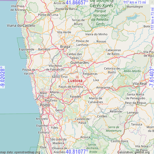
Lustosa GPS coordinates[2]
41° 20' 26.916" North, 8° 19' 1.74" West
| Map corner | latitude | longitude |
|---|---|---|
| Upper-left | 41.86657°, | -9.02028° |
| Center: | 41.34081°, | -8.31715° |
| Lower-right: | 40.81077°, | -7.61403° |
| Map W x H: | 117.4×117.4 km | = 72.9×72.9mi |
| max Lat: | 42.11337° ⇑15.3% North |
| Lustosa: | 41.34081° |
| min Lat: | ⇓84.7% South 32.6448° |
| min Long | Lustosa | max Long |
| -31.17847° | -8.31715° | -6.27308° |
| W 67.9%⇐ | ⇒32.1% E |
Elevation
Elevation of Lustosa is 393 m = 1289 ft, and this is 216 m = 709 ft above average elevation for this country.
| Max E: |
1008 m = 3307 ft | 13.3% |
| Lustosa | 393 m 1289 ft | |
| Avg. | 177 m = 581 ft | |
Min E: |
-128 m = -420 ft | 86.7% |
See also: Portugal elevation on elevation.city.
Geographical zone
Lustosa is located in North temperate zone (between Tropic of Cancer and the Arctic Circle). Distance of this Northern Tropic circle is 1990.7 km =1237 mi to South.| Distance of | km | miles | from Lustosa |
|---|---|---|---|
| North Pole | 5410.4 | 3361.9 | to North |
| Arctic Circle | 2804.5 | 1742.6 | to North |
| Tropic Cancer | 1990.7 | 1237 | to South |
| Equator | 4596.7 | 2856.3 | to South |


Nearby cities:
15 places around Lustosa: (largest is in red/bold)
• Aves
8.4 km =5.2 mi,  292°
292°
• Barrosas
2.2 km =1.4 mi,  42°
42°
• Caldas de Vizela
4.6 km =2.9 mi,  8°
8°
• Carvalhosa
5.8 km =3.6 mi,  219°
219°
• Ferreira
8.5 km =5.3 mi,  195°
195°
• Freamunde
6 km =3.7 mi,  194°
194°
• Lordelo
6.4 km =4 mi,  305°
305°
• Lousada
7.6 km =4.7 mi,  155°
155°
• Moreira de Conegos
5.4 km =3.4 mi,  340°
340°
• Negrelos
7.1 km =4.4 mi,  277°
277°
• Riba de Ave
8.5 km =5.3 mi,  316°
316°
• Serzedelo
8 km =5 mi,  327°
327°
• Vilarinho
2.4 km =1.5 mi, 330°
• Vizela
7.1 km =4.4 mi, 38°
• Vizela
7.3 km =4.5 mi,  50°
50°
Sources, notices
• [Note1] Compared only with cities in Portugal existing in our database
• [Src1] Map data: © OpenStreetMap contributors (CC-BY-SA)
• [Src2] Other city data from geonames.org with taken over terms of usage.
• [Src3] Geographical zone / Annual Mean Temperature by Robert A. Rohde @ Wikipedia
