Vila Meã geodata
Vila Meã (Porto) is a populated place; located in Portugal in Europe/Lisbon (GMT+1) time zone. With population of 5,000 people, there are 423 cities with bigger population in this country. Compared to other cities in Portugal, 81.6% of cities are located further ↓South; 73.8% of cities are located further ←West and 62.1% of cities have lower elevation than Vila Meã. Note1


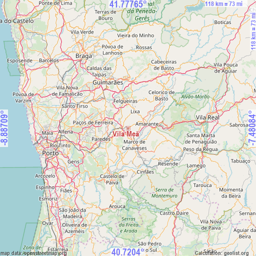
Vila Meã GPS coordinates[2]
41° 15' 4.176" North, 8° 11' 2.292" West
| Map corner | latitude | longitude |
|---|---|---|
| Upper-left | 41.77765°, | -8.88709° |
| Center: | 41.25116°, | -8.18397° |
| Lower-right: | 40.7204°, | -7.48084° |
| Map W x H: | 117.6×117.6 km | = 73.1×73.1mi |
| max Lat: | 42.11337° ⇑18.4% North |
| Vila Meã: | 41.25116° |
| min Lat: | ⇓81.6% South 32.6448° |
| min Long | Vila Meã | max Long |
| -31.17847° | -8.18397° | -6.27308° |
| W 73.8%⇐ | ⇒26.2% E |
Elevation
Elevation of Vila Meã is 166 m = 545 ft, and this is 11 m = 36 ft below average elevation for this country.
| Max E: |
1008 m = 3307 ft | 37.9% |
| Avg. | 177 m = 581 ft | |
| Vila Meã | 166 m = 545 ft | |
Min E: |
-128 m = -420 ft | 62.1% |
See also: Portugal elevation on elevation.city.
Geographical zone
Vila Meã is located in North temperate zone (between Tropic of Cancer and the Arctic Circle). Distance of this Northern Tropic circle is 1980.8 km =1230.8 mi to South.| Distance of | km | miles | from Vila Meã |
|---|---|---|---|
| North Pole | 5420.4 | 3368.1 | to North |
| Arctic Circle | 2814.5 | 1748.8 | to North |
| Tropic Cancer | 1980.8 | 1230.8 | to South |
| Equator | 4586.7 | 2850 | to South |


Nearby cities:
15 places around Vila Meã: (largest is in red/bold)
• Amarante
8.8 km =5.5 mi,  74°
74°
• Felgueiras
13 km =8.1 mi,  356°
356°
• Ferreira
13.5 km =8.4 mi,  277°
277°
• Figueiró
5.5 km =3.4 mi,  14°
14°
• Freamunde
13.3 km =8.3 mi,  288°
288°
• Lousada
8.6 km =5.3 mi, 290°
• Madalena
13.2 km =8.2 mi,  252°
252°
• Marco de Canavezes
8 km =5 mi,  158°
158°
• Margaride
12.7 km =7.9 mi,  353°
353°
• Meinedo
6.2 km =3.9 mi,  267°
267°
• Paredes
13.4 km =8.3 mi, 247°
• Penafiel
9.5 km =5.9 mi,  240°
240°
• Perafita
9.6 km =6 mi,  217°
217°
• Santo Izidoro
5.7 km =3.5 mi,  142°
142°
• Telões
9 km =5.6 mi,  42°
42°
Sources, notices
• [Note1] Compared only with cities in Portugal existing in our database
• [Src1] Map data: © OpenStreetMap contributors (CC-BY-SA)
• [Src2] Other city data from geonames.org with taken over terms of usage.
• [Src3] Geographical zone / Annual Mean Temperature by Robert A. Rohde @ Wikipedia
