Bougado geodata
Bougado (Porto) is a populated place; located in Portugal in Europe/Lisbon (GMT+1) time zone. With population of 21,680 people, there are 85 cities with bigger population in this country. Compared to other cities in Portugal, 84.5% of cities are located further ↓South; 50.9% of cities are located further ←West and 78.1% of cities have higher elevation than Bougado. Note1


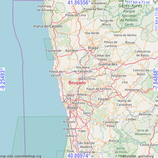
Bougado GPS coordinates[2]
41° 20' 23.244" North, 8° 33' 6.48" West
| Map corner | latitude | longitude |
|---|---|---|
| Upper-left | 41.86556°, | -9.25493° |
| Center: | 41.33979°, | -8.5518° |
| Lower-right: | 40.80974°, | -7.84868° |
| Map W x H: | 117.4×117.4 km | = 72.9×72.9mi |
| max Lat: | 42.11337° ⇑15.5% North |
| Bougado: | 41.33979° |
| min Lat: | ⇓84.5% South 32.6448° |
| min Long | Bougado | max Long |
| -31.17847° | -8.5518° | -6.27308° |
| W 50.9%⇐ | ⇒49.1% E |
Elevation
Elevation of Bougado is 35 m = 115 ft, and this is 142 m = 466 ft below average elevation for this country.
| Max E: |
1008 m = 3307 ft | 78.1% |
| Avg. | 177 m = 581 ft | |
| Bougado | 35 m = 115 ft | |
Min E: |
-128 m = -420 ft | 21.9% |
See also: Portugal elevation on elevation.city.
Geographical zone
Bougado is located in North temperate zone (between Tropic of Cancer and the Arctic Circle). Distance of this Northern Tropic circle is 1990.6 km =1236.9 mi to South.| Distance of | km | miles | from Bougado |
|---|---|---|---|
| North Pole | 5410.5 | 3361.9 | to North |
| Arctic Circle | 2804.6 | 1742.7 | to North |
| Tropic Cancer | 1990.6 | 1236.9 | to South |
| Equator | 4596.6 | 2856.2 | to South |


Nearby cities:
15 places around Bougado: (largest is in red/bold)
• Anta
10.4 km =6.5 mi,  218°
218°
• Balazar
9.4 km =5.8 mi,  320°
320°
• Calendário
7.3 km =4.5 mi,  14°
14°
• Ferreiros
1.1 km =0.7 mi, 7°
• Fradelos
5.1 km =3.2 mi,  309°
309°
• Lamelas
8.7 km =5.4 mi,  132°
132°
• Rebordões
10.8 km =6.7 mi,  80°
80°
• Ribeirão
2.7 km =1.7 mi,  330°
330°
• Santo Tirso
6.2 km =3.9 mi,  87°
87°
• São Miguel do Couto
7.6 km =4.7 mi,  96°
96°
• São Romão do Coronado
6.1 km =3.8 mi,  188°
188°
• Trofa
0.7 km =0.4 mi,  246°
246°
• Vairão
9.6 km =6 mi,  265°
265°
• Vila Nova de Famalicão
8 km =5 mi,  19°
19°
• Água Longa
11.2 km =7 mi,  153°
153°
Sources, notices
• [Note1] Compared only with cities in Portugal existing in our database
• [Src1] Map data: © OpenStreetMap contributors (CC-BY-SA)
• [Src2] Other city data from geonames.org with taken over terms of usage.
• [Src3] Geographical zone / Annual Mean Temperature by Robert A. Rohde @ Wikipedia
