Rebordões geodata
Rebordões (Porto) is a populated place; located in Portugal in Europe/Lisbon (GMT+1) time zone. With population of 3,368 people, there are 568 cities with bigger population in this country. Compared to other cities in Portugal, 85.4% of cities are located further ↓South; 60.9% of cities are located further ←West and 51.9% of cities have higher elevation than Rebordões. Note1


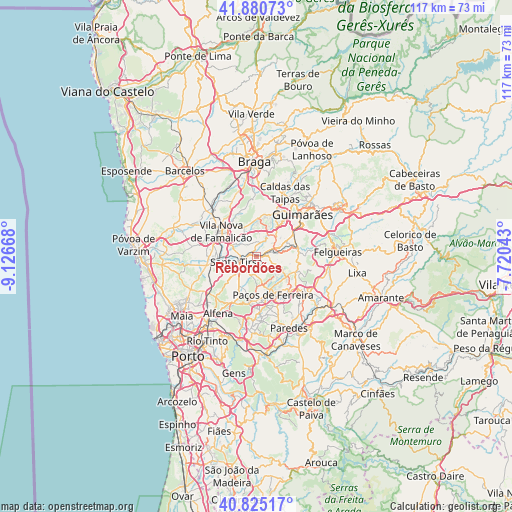
Rebordões GPS coordinates[2]
41° 21' 18.324" North, 8° 25' 24.78" West
| Map corner | latitude | longitude |
|---|---|---|
| Upper-left | 41.88073°, | -9.12668° |
| Center: | 41.35509°, | -8.42355° |
| Lower-right: | 40.82517°, | -7.72043° |
| Map W x H: | 117.4×117.4 km | = 72.9×72.9mi |
| max Lat: | 42.11337° ⇑14.6% North |
| Rebordões: | 41.35509° |
| min Lat: | ⇓85.4% South 32.6448° |
| min Long | Rebordões | max Long |
| -31.17847° | -8.42355° | -6.27308° |
| W 60.9%⇐ | ⇒39.1% E |
Elevation
Elevation of Rebordões is 105 m = 344 ft, and this is 72 m = 236 ft below average elevation for this country.
| Max E: |
1008 m = 3307 ft | 51.9% |
| Avg. | 177 m = 581 ft | |
| Rebordões | 105 m = 344 ft | |
Min E: |
-128 m = -420 ft | 48.1% |
See also: Portugal elevation on elevation.city.
Geographical zone
Rebordões is located in North temperate zone (between Tropic of Cancer and the Arctic Circle). Distance of this Northern Tropic circle is 1992.3 km =1238 mi to South.| Distance of | km | miles | from Rebordões |
|---|---|---|---|
| North Pole | 5408.8 | 3360.9 | to North |
| Arctic Circle | 2802.9 | 1741.6 | to North |
| Tropic Cancer | 1992.3 | 1238 | to South |
| Equator | 4598.3 | 2857.3 | to South |


Nearby cities:
15 places around Rebordões: (largest is in red/bold)
• Aves
2 km =1.2 mi,  33°
33°
• Carvalhosa
8 km =5 mi,  139°
139°
• Joane
9.4 km =5.8 mi,  7°
7°
• Lamelas
8.6 km =5.3 mi,  209°
209°
• Lordelo
4.2 km =2.6 mi,  59°
59°
• Lustosa
9 km =5.6 mi,  100°
100°
• Moreira de Conegos
7.9 km =4.9 mi, 63°
• Negrelos
1.9 km =1.2 mi,  108°
108°
• Paços de Ferreira
9.6 km =6 mi,  155°
155°
• Riba de Ave
5.5 km =3.4 mi, 33°
• Santo Tirso
4.7 km =2.9 mi,  252°
252°
• Selho
9.6 km =6 mi,  42°
42°
• Serzedelo
6.9 km =4.3 mi, 41°
• São Miguel do Couto
4.1 km =2.5 mi,  230°
230°
• Vilarinho
7.7 km =4.8 mi,  86°
86°
Sources, notices
• [Note1] Compared only with cities in Portugal existing in our database
• [Src1] Map data: © OpenStreetMap contributors (CC-BY-SA)
• [Src2] Other city data from geonames.org with taken over terms of usage.
• [Src3] Geographical zone / Annual Mean Temperature by Robert A. Rohde @ Wikipedia
