Lamelas geodata
Lamelas (Porto) is a populated place; located in Portugal in Europe/Lisbon (GMT+1) time zone. With population of 953 people, there are 761 cities with bigger population in this country. Compared to other cities in Portugal, 83.1% of cities are located further ↓South; 56.3% of cities are located further ←West and 61.2% of cities have lower elevation than Lamelas. Note1


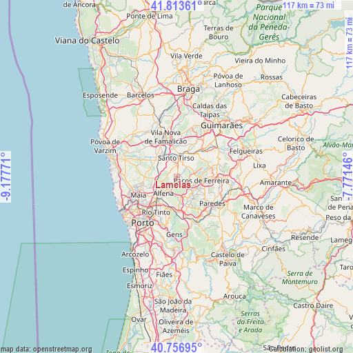
Lamelas GPS coordinates[2]
41° 17' 14.712" North, 8° 28' 28.488" West
| Map corner | latitude | longitude |
|---|---|---|
| Upper-left | 41.81361°, | -9.17771° |
| Center: | 41.28742°, | -8.47458° |
| Lower-right: | 40.75695°, | -7.77146° |
| Map W x H: | 117.5×117.5 km | = 73×73mi |
| max Lat: | 42.11337° ⇑16.9% North |
| Lamelas: | 41.28742° |
| min Lat: | ⇓83.1% South 32.6448° |
| min Long | Lamelas | max Long |
| -31.17847° | -8.47458° | -6.27308° |
| W 56.3%⇐ | ⇒43.7% E |
Elevation
Elevation of Lamelas is 161 m = 528 ft, and this is 16 m = 52 ft below average elevation for this country.
| Max E: |
1008 m = 3307 ft | 38.8% |
| Avg. | 177 m = 581 ft | |
| Lamelas | 161 m = 528 ft | |
Min E: |
-128 m = -420 ft | 61.2% |
See also: Portugal elevation on elevation.city.
Geographical zone
Lamelas is located in North temperate zone (between Tropic of Cancer and the Arctic Circle). Distance of this Northern Tropic circle is 1984.8 km =1233.3 mi to South.| Distance of | km | miles | from Lamelas |
|---|---|---|---|
| North Pole | 5416.3 | 3365.5 | to North |
| Arctic Circle | 2810.4 | 1746.3 | to North |
| Tropic Cancer | 1984.8 | 1233.3 | to South |
| Equator | 4590.7 | 2852.5 | to South |


Nearby cities:
15 places around Lamelas: (largest is in red/bold)
• Alfena
7 km =4.3 mi,  216°
216°
• Bougado
8.7 km =5.4 mi,  312°
312°
• Frazão
7 km =4.3 mi,  117°
117°
• Lordelo
8.4 km =5.2 mi,  134°
134°
• Negrelos
9.2 km =5.7 mi,  41°
41°
• Paços de Ferreira
8.3 km =5.2 mi,  98°
98°
• Rebordosa
9 km =5.6 mi,  141°
141°
• Rebordões
8.6 km =5.3 mi,  29°
29°
• Santo Tirso
6.1 km =3.8 mi,  357°
357°
• Seroa
4.6 km =2.9 mi, 123°
• Sobrado
8.7 km =5.4 mi,  169°
169°
• São Miguel do Couto
5 km =3.1 mi,  12°
12°
• São Romão do Coronado
7.4 km =4.6 mi,  268°
268°
• Trofa
9 km =5.6 mi, 307°
• Água Longa
4.5 km =2.8 mi,  200°
200°
Sources, notices
• [Note1] Compared only with cities in Portugal existing in our database
• [Src1] Map data: © OpenStreetMap contributors (CC-BY-SA)
• [Src2] Other city data from geonames.org with taken over terms of usage.
• [Src3] Geographical zone / Annual Mean Temperature by Robert A. Rohde @ Wikipedia
