Yhú geodata
Yhú (Caaguazú) is a seat of a second-order administrative division; located in Paraguay in America/Asuncion (GMT-4) time zone. With population of 2,092 people, there are 109 cities with bigger population in this country. Compared to other cities in Paraguay, 74.1% of cities are located further ↓South; 74.1% of cities are located further ←West and 93.2% of cities have lower elevation than Yhú. Note1


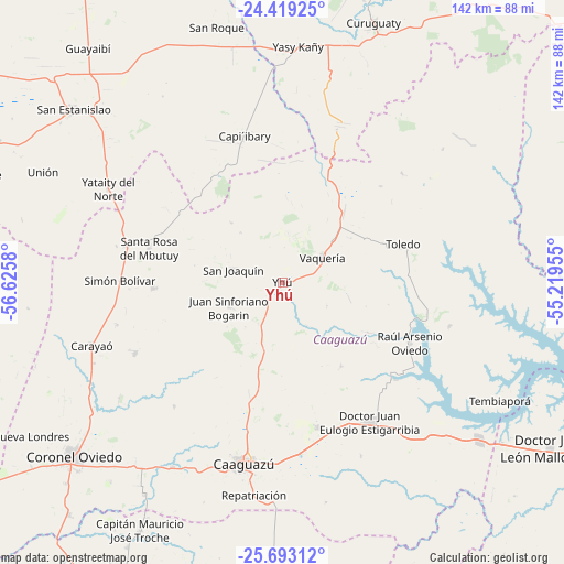
Yhú GPS coordinates[2]
25° 3' 28.224" South, 55° 55' 21.612" West
| Map corner | latitude | longitude |
|---|---|---|
| Upper-left | -24.41925°, | -56.6258° |
| Center: | -25.05784°, | -55.92267° |
| Lower-right: | -25.69312°, | -55.21955° |
| Map W x H: | 141.6×141.6 km | = 88×88mi |
| max Lat: | -19.91667° ⇑25.9% North |
| Yhú: | -25.05784° |
| min Lat: | ⇓74.1% South -27.38662° |
| min Long | Yhú | max Long |
| -60.78333° | -55.92267° | -54.30694° |
| W 74.1%⇐ | ⇒25.9% E |
Elevation
Elevation of Yhú is 320 m = 1050 ft, and this is 150.3 m = 493 ft above average elevation for this country.
| Max E: |
658 m = 2159 ft | 6.8% |
| Yhú | 320 m 1050 ft | |
| Avg. | 169.7 m = 557 ft | |
Min E: |
46 m = 151 ft | 93.2% |
See also: Paraguay elevation on elevation.city.
Geographical zone
Yhú is located in South temperate zone (between Tropic of Capricorn and the Antarctic Circle). Distance of this Southern Tropic circle is 180.3 km =112 mi to North.| Distance of | km | miles | from Yhú |
|---|---|---|---|
| Equator | 2786.2 | 1731.3 | to North |
| Tropic Capricorn | 180.3 | 112 | to North |
| Antarctic Circle | 4615 | 2867.6 | to South |
| South Pole | 7220.9 | 4486.9 | to South |


Nearby cities:
15 places around Yhú: (largest is in red/bold)
• Caaguazú
46.9 km =29.1 mi,  191°
191°
• Capiíbary
30.8 km =19.1 mi,  338°
338°
• Carayaó
50.4 km =31.3 mi,  252°
252°
• Cecilio Baez
32.4 km =20.1 mi,  267°
267°
• Colonia General Alfredo Stroessner
40.4 km =25.1 mi,  147°
147°
• Colonia Mauricio José Troche
67.2 km =41.8 mi,  212°
212°
• Coronel Oviedo
67.5 km =41.9 mi,  230°
230°
• Doctor Juan Manuel Frutos
37.4 km =23.2 mi,  165°
165°
• Mbutuý
40 km =24.9 mi,  283°
283°
• Nueva Londres
73.9 km =45.9 mi,  238°
238°
• Repatriación
52.9 km =32.9 mi,  182°
182°
• San Isidro de Curuguaty
69.2 km =43 mi,  19°
19°
• San Joaquín
12.5 km =7.8 mi,  285°
285°
• Unión
66.5 km =41.3 mi, 294°
• Yataity del Norte
49.8 km =30.9 mi,  300°
300°
Sources, notices
• [Note1] Compared only with cities in Paraguay existing in our database
• [Src1] Map data: © OpenStreetMap contributors (CC-BY-SA)
• [Src2] Other city data from geonames.org with taken over terms of usage.
• [Src3] Geographical zone / Annual Mean Temperature by Robert A. Rohde @ Wikipedia
