Caaguazú geodata
Caaguazú is a populated place; located in Paraguay in America/Asuncion (GMT-4) time zone. With population of 54,808 people, there are 15 cities with bigger population in this country. Compared to other cities in Paraguay, 50.6% of cities are located further ↓South; 71% of cities are located further ←West and 94.4% of cities have lower elevation than Caaguazú. Note1


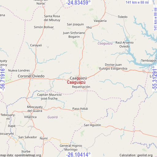
Caaguazú GPS coordinates[2]
25° 28' 15.744" South, 56° 0' 57.708" West
| Map corner | latitude | longitude |
|---|---|---|
| Upper-left | -24.83459°, | -56.71916° |
| Center: | -25.47104°, | -56.01603° |
| Lower-right: | -26.10414°, | -55.31291° |
| Map W x H: | 141.2×141.2 km | = 87.7×87.7mi |
| max Lat: | -19.91667° ⇑49.4% North |
| Caaguazú: | -25.47104° |
| min Lat: | ⇓50.6% South -27.38662° |
| min Long | Caaguazú | max Long |
| -60.78333° | -56.01603° | -54.30694° |
| W 71%⇐ | ⇒29% E |
Elevation
Elevation of Caaguazú is 336 m = 1102 ft, and this is 166.3 m = 546 ft above average elevation for this country.
| Max E: |
658 m = 2159 ft | 5.6% |
| Caaguazú | 336 m 1102 ft | |
| Avg. | 169.7 m = 557 ft | |
Min E: |
46 m = 151 ft | 94.4% |
See also: Caaguazú elevation on elevation.city.
Geographical zone
Caaguazú is located in South temperate zone (between Tropic of Capricorn and the Antarctic Circle). Distance of this Southern Tropic circle is 226.2 km =140.6 mi to North.| Distance of | km | miles | from Caaguazú |
|---|---|---|---|
| Equator | 2832.1 | 1759.8 | to North |
| Tropic Capricorn | 226.2 | 140.6 | to North |
| Antarctic Circle | 4569.1 | 2839.1 | to South |
| South Pole | 7174.9 | 4458.3 | to South |


Nearby cities:
15 places around Caaguazú: (largest is in red/bold)
• Carayaó
49 km =30.4 mi,  308°
308°
• Cecilio Baez
50 km =31.1 mi,  332°
332°
• Colonia General Alfredo Stroessner
33.3 km =20.7 mi,  69°
69°
• Colonia Mauricio José Troche
28.9 km =18 mi,  248°
248°
• Coronel Oviedo
42.7 km =26.5 mi,  273°
273°
• Doctor Juan Manuel Frutos
20.9 km =13 mi,  62°
62°
• General Higinio Morínigo
54.2 km =33.7 mi,  169°
169°
• Independencia
35.2 km =21.9 mi,  225°
225°
• Mbocayaty
49.2 km =30.6 mi,  235°
235°
• Natalicio Talavera
33.7 km =20.9 mi, 237°
• Nueva Londres
54.1 km =33.6 mi,  277°
277°
• Repatriación
9.6 km =6 mi,  136°
136°
• San Joaquín
49.3 km =30.6 mi,  356°
356°
• Villarrica
52.2 km =32.4 mi, 233°
• Yhú
46.9 km =29.1 mi,  11°
11°
Sources, notices
• [Note1] Compared only with cities in Paraguay existing in our database
• [Src1] Map data: © OpenStreetMap contributors (CC-BY-SA)
• [Src2] Other city data from geonames.org with taken over terms of usage.
• [Src3] Geographical zone / Annual Mean Temperature by Robert A. Rohde @ Wikipedia
