San Joaquín geodata
San Joaquín (Caaguazú) is a seat of a second-order administrative division; located in Paraguay in America/Asuncion (GMT-4) time zone. With population of 1,745 people, there are 116 cities with bigger population in this country. Compared to other cities in Paraguay, 75.3% of cities are located further ↓South; 69.8% of cities are located further ←West and 95.1% of cities have lower elevation than San Joaquín. Note1


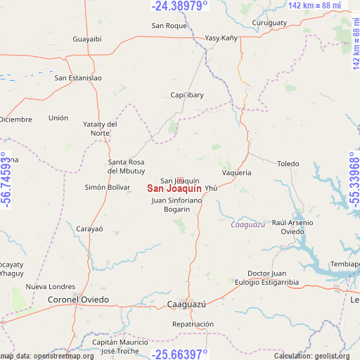
San Joaquín GPS coordinates[2]
25° 1' 42.708" South, 56° 2' 34.08" West
| Map corner | latitude | longitude |
|---|---|---|
| Upper-left | -24.38979°, | -56.74593° |
| Center: | -25.02853°, | -56.0428° |
| Lower-right: | -25.66397°, | -55.33968° |
| Map W x H: | 141.7×141.7 km | = 88×88mi |
| max Lat: | -19.91667° ⇑24.7% North |
| San Joaquín: | -25.02853° |
| min Lat: | ⇓75.3% South -27.38662° |
| min Long | San Joaquín | max Long |
| -60.78333° | -56.0428° | -54.30694° |
| W 69.8%⇐ | ⇒30.2% E |
Elevation
Elevation of San Joaquín is 346 m = 1135 ft, and this is 176.3 m = 578 ft above average elevation for this country.
| Max E: |
658 m = 2159 ft | 4.9% |
| San Joaquín | 346 m 1135 ft | |
| Avg. | 169.7 m = 557 ft | |
Min E: |
46 m = 151 ft | 95.1% |
See also: Paraguay elevation on elevation.city.
Geographical zone
San Joaquín is located in South temperate zone (between Tropic of Capricorn and the Antarctic Circle). Distance of this Southern Tropic circle is 177 km =110 mi to North.| Distance of | km | miles | from San Joaquín |
|---|---|---|---|
| Equator | 2782.9 | 1729.2 | to North |
| Tropic Capricorn | 177 | 110 | to North |
| Antarctic Circle | 4618.3 | 2869.7 | to South |
| South Pole | 7224.2 | 4488.9 | to South |


Nearby cities:
15 places around San Joaquín: (largest is in red/bold)
• Caaguazú
49.3 km =30.6 mi,  176°
176°
• Capiíbary
25.4 km =15.8 mi,  2°
2°
• Carayaó
40.5 km =25.2 mi,  242°
242°
• Cecilio Baez
20.8 km =12.9 mi,  256°
256°
• Colonia General Alfredo Stroessner
50.3 km =31.3 mi,  137°
137°
• Colonia Mauricio José Troche
64.5 km =40.1 mi,  202°
202°
• Coronel Oviedo
61.1 km =38 mi,  220°
220°
• Doctor Juan Manuel Frutos
44.8 km =27.8 mi,  151°
151°
• Mbutuý
27.5 km =17.1 mi,  282°
282°
• Nueva Londres
65.9 km =40.9 mi,  230°
230°
• Repatriación
56.9 km =35.4 mi,  170°
170°
• Unión
54.1 km =33.6 mi,  296°
296°
• Veinticinco de Diciembre
62.9 km =39.1 mi,  305°
305°
• Yataity del Norte
37.8 km =23.5 mi, 305°
• Yhú
12.5 km =7.8 mi,  105°
105°
Sources, notices
• [Note1] Compared only with cities in Paraguay existing in our database
• [Src1] Map data: © OpenStreetMap contributors (CC-BY-SA)
• [Src2] Other city data from geonames.org with taken over terms of usage.
• [Src3] Geographical zone / Annual Mean Temperature by Robert A. Rohde @ Wikipedia
