Villa Hayes geodata
Villa Hayes (Presidente Hayes) is a seat of a first-order administrative division; located in Paraguay in America/Asuncion (GMT-4) time zone. With population of 57,217 people, there are 13 cities with bigger population in this country. Compared to other cities in Paraguay, 72.8% of cities are located further ↓South; 88.3% of cities are located further →East and 92% of cities have higher elevation than Villa Hayes. Note1


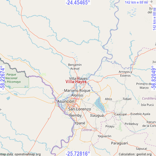
Villa Hayes GPS coordinates[2]
25° 5' 35.016" South, 57° 31' 24.996" West
| Map corner | latitude | longitude |
|---|---|---|
| Upper-left | -24.45465°, | -58.22674° |
| Center: | -25.09306°, | -57.52361° |
| Lower-right: | -25.72816°, | -56.82049° |
| Map W x H: | 141.6×141.6 km | = 88×88mi |
| max Lat: | -19.91667° ⇑27.2% North |
| Villa Hayes: | -25.09306° |
| min Lat: | ⇓72.8% South -27.38662° |
| min Long | Villa Hayes | max Long |
| -60.78333° | -57.52361° | -54.30694° |
| W 11.7%⇐ | ⇒88.3% E |
Elevation
Elevation of Villa Hayes is 75 m = 246 ft, and this is 94.7 m = 311 ft below average elevation for this country.
| Max E: |
658 m = 2159 ft | 92% |
| Avg. | 169.7 m = 557 ft | |
| Villa Hayes | 75 m = 246 ft | |
Min E: |
46 m = 151 ft | 8% |
See also: Villa Hayes elevation on elevation.city.
Geographical zone
Villa Hayes is located in South temperate zone (between Tropic of Capricorn and the Antarctic Circle). Distance of this Southern Tropic circle is 184.2 km =114.5 mi to North.| Distance of | km | miles | from Villa Hayes |
|---|---|---|---|
| Equator | 2790.1 | 1733.7 | to North |
| Tropic Capricorn | 184.2 | 114.5 | to North |
| Antarctic Circle | 4611.1 | 2865.2 | to South |
| South Pole | 7217 | 4484.4 | to South |


Nearby cities:
15 places around Villa Hayes: (largest is in red/bold)
• Altos
33 km =20.5 mi,  124°
124°
• Areguá
28.1 km =17.5 mi,  150°
150°
• Asunción
24.8 km =15.4 mi,  209°
209°
• Benjamín Aceval
14.7 km =9.1 mi,  342°
342°
• Capiatá
30.2 km =18.8 mi,  164°
164°
• Emboscada
18.6 km =11.6 mi,  109°
109°
• Fernando de la Mora
27.3 km =17 mi,  179°
179°
• Lambaré
29.4 km =18.3 mi,  196°
196°
• Limpio
9 km =5.6 mi, 154°
• Mariano Roque Alonso
12.8 km =8 mi, 183°
• Nanawua
27.5 km =17.1 mi,  221°
221°
• Nueva Colombia
20.2 km =12.6 mi, 119°
• San Bernardino
33.3 km =20.7 mi,  136°
136°
• San Lorenzo
27.5 km =17.1 mi, 176°
• Villa Elisa
31.3 km =19.4 mi,  192°
192°
Sources, notices
• [Note1] Compared only with cities in Paraguay existing in our database
• [Src1] Map data: © OpenStreetMap contributors (CC-BY-SA)
• [Src2] Other city data from geonames.org with taken over terms of usage.
• [Src3] Geographical zone / Annual Mean Temperature by Robert A. Rohde @ Wikipedia
