Limpio geodata
Limpio (Central) is a populated place; located in Paraguay in America/Asuncion (GMT-4) time zone. With population of 96,143 people, there are 6 cities with bigger population in this country. Compared to other cities in Paraguay, 71% of cities are located further ↓South; 86.4% of cities are located further →East and 93.2% of cities have higher elevation than Limpio. Note1


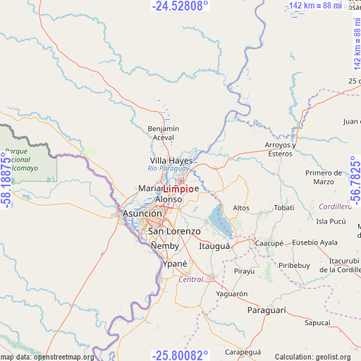
Limpio GPS coordinates[2]
25° 9' 57.996" South, 57° 29' 8.232" West
| Map corner | latitude | longitude |
|---|---|---|
| Upper-left | -24.52808°, | -58.18875° |
| Center: | -25.16611°, | -57.48562° |
| Lower-right: | -25.80082°, | -56.7825° |
| Map W x H: | 141.5×141.5 km | = 87.9×87.9mi |
| max Lat: | -19.91667° ⇑29% North |
| Limpio: | -25.16611° |
| min Lat: | ⇓71% South -27.38662° |
| min Long | Limpio | max Long |
| -60.78333° | -57.48562° | -54.30694° |
| W 13.6%⇐ | ⇒86.4% E |
Elevation
Elevation of Limpio is 74 m = 243 ft, and this is 95.7 m = 314 ft below average elevation for this country.
| Max E: |
658 m = 2159 ft | 93.2% |
| Avg. | 169.7 m = 557 ft | |
| Limpio | 74 m = 243 ft | |
Min E: |
46 m = 151 ft | 6.8% |
See also: Limpio elevation on elevation.city.
Geographical zone
Limpio is located in South temperate zone (between Tropic of Capricorn and the Antarctic Circle). Distance of this Southern Tropic circle is 192.3 km =119.5 mi to North.| Distance of | km | miles | from Limpio |
|---|---|---|---|
| Equator | 2798.2 | 1738.7 | to North |
| Tropic Capricorn | 192.3 | 119.5 | to North |
| Antarctic Circle | 4603 | 2860.2 | to South |
| South Pole | 7208.9 | 4479.4 | to South |


Nearby cities:
15 places around Limpio: (largest is in red/bold)
• Altos
25.6 km =15.9 mi,  114°
114°
• Areguá
19.2 km =11.9 mi,  148°
148°
• Asunción
21 km =13 mi,  230°
230°
• Benjamín Aceval
23.6 km =14.7 mi,  339°
339°
• Capiatá
21.4 km =13.3 mi,  169°
169°
• Emboscada
13.8 km =8.6 mi,  82°
82°
• Fernando de la Mora
19.5 km =12.1 mi,  190°
190°
• Lambaré
23.5 km =14.6 mi,  211°
211°
• Mariano Roque Alonso
6.6 km =4.1 mi, 225°
• Nanawua
25.2 km =15.7 mi,  240°
240°
• Nueva Colombia
13.8 km =8.6 mi,  97°
97°
• San Bernardino
24.9 km =15.5 mi,  130°
130°
• San Lorenzo
19.4 km =12.1 mi, 186°
• Villa Elisa
24.9 km =15.5 mi, 205°
• Villa Hayes
9 km =5.6 mi,  334°
334°
Sources, notices
• [Note1] Compared only with cities in Paraguay existing in our database
• [Src1] Map data: © OpenStreetMap contributors (CC-BY-SA)
• [Src2] Other city data from geonames.org with taken over terms of usage.
• [Src3] Geographical zone / Annual Mean Temperature by Robert A. Rohde @ Wikipedia
