Veinticinco de Diciembre geodata
Veinticinco de Diciembre (San Pedro) is a populated place; located in Paraguay in America/Asuncion (GMT-4) time zone. With population of 766 people, there are 149 cities with bigger population in this country. Compared to other cities in Paraguay, 80.9% of cities are located further ↓South; 51.9% of cities are located further ←West and 74.1% of cities have higher elevation than Veinticinco de Diciembre. Note1
Current local time in Veinticinco de Diciembre:
04:00 PM, ThursdayDifference from your time zone: hours


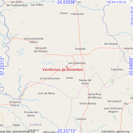
Veinticinco de Diciembre GPS coordinates[2]
24° 42' 0" South, 56° 33' 0" West
| Map corner | latitude | longitude |
|---|---|---|
| Upper-left | -24.05958°, | -57.25313° |
| Center: | -24.7°, | -56.55° |
| Lower-right: | -25.33715°, | -55.84688° |
| Map W x H: | 142.1×142.1 km | = 88.3×88.3mi |
| max Lat: | -19.91667° ⇑19.1% North |
| Veinticinco de Diciembre: | -24.7° |
| min Lat: | ⇓80.9% South -27.38662° |
| min Long | Veinticinco de | max Long |
| -60.78333° | -56.55° | -54.30694° |
| W 51.9%⇐ | ⇒48.1% E |
Elevation
Elevation of Veinticinco de Diciembre is 119 m = 390 ft, and this is 50.7 m = 166 ft below average elevation for this country.
| Max E: |
658 m = 2159 ft | 74.1% |
| Avg. | 169.7 m = 557 ft | |
| Veinticinco de Diciembre | 119 m = 390 ft | |
Min E: |
46 m = 151 ft | 25.9% |
See also: Paraguay elevation on elevation.city.
Geographical zone
Veinticinco de Diciembre is located in South temperate zone (between Tropic of Capricorn and the Antarctic Circle). Distance of this Southern Tropic circle is 140.5 km =87.3 mi to North.| Distance of | km | miles | from Veinticinco de Diciembre |
|---|---|---|---|
| Equator | 2746.4 | 1706.5 | to North |
| Tropic Capricorn | 140.5 | 87.3 | to North |
| Antarctic Circle | 4654.8 | 2892.4 | to South |
| South Pole | 7260.7 | 4511.6 | to South |


Nearby cities:
15 places around Veinticinco de Diciembre: (largest is in red/bold)
• Arroyos y Esteros
68 km =42.3 mi,  234°
234°
• Capiíbary
53.3 km =33.1 mi,  102°
102°
• Caraguatay
66.1 km =41.1 mi,  204°
204°
• Carayaó
57.4 km =35.7 mi,  164°
164°
• Cecilio Baez
51.6 km =32.1 mi,  143°
143°
• Chore
57.2 km =35.5 mi,  356°
356°
• General Elizardo Aquino
45.5 km =28.3 mi,  308°
308°
• Guayaybi
22 km =13.7 mi,  32°
32°
• Itacurubí del Rosario
33.2 km =20.6 mi,  303°
303°
• Mbutuý
39.1 km =24.3 mi, 141°
• Primero de Marzo
63.2 km =39.3 mi,  217°
217°
• Puerto Rosario
66.5 km =41.3 mi, 295°
• San Joaquín
62.9 km =39.1 mi,  125°
125°
• Unión
12.3 km =7.6 mi,  166°
166°
• Yataity del Norte
25.1 km =15.6 mi, 126°
Sources, notices
• [Note1] Compared only with cities in Paraguay existing in our database
• [Src1] Map data: © OpenStreetMap contributors (CC-BY-SA)
• [Src2] Other city data from geonames.org with taken over terms of usage.
• [Src3] Geographical zone / Annual Mean Temperature by Robert A. Rohde @ Wikipedia
