Chore geodata
Chore (San Pedro) is a seat of a second-order administrative division; located in Paraguay in America/Asuncion (GMT-4) time zone. In our database, there are 162 cities with bigger population. Compared to other cities in Paraguay, 85.2% of cities are located further ↓South; 51.2% of cities are located further ←West and 67.3% of cities have lower elevation than Chore. Note1


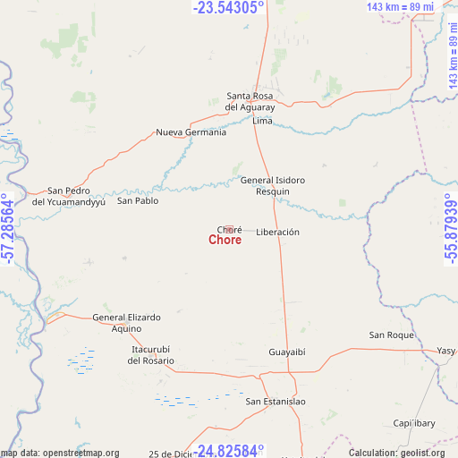
Chore GPS coordinates[2]
24° 11' 9.816" South, 56° 34' 57.036" West
| Map corner | latitude | longitude |
|---|---|---|
| Upper-left | -23.54305°, | -57.28564° |
| Center: | -24.18606°, | -56.58251° |
| Lower-right: | -24.82584°, | -55.87939° |
| Map W x H: | 142.6×142.6 km | = 88.6×88.6mi |
| max Lat: | -19.91667° ⇑14.8% North |
| Chore: | -24.18606° |
| min Lat: | ⇓85.2% South -27.38662° |
| min Long | Chore | max Long |
| -60.78333° | -56.58251° | -54.30694° |
| W 51.2%⇐ | ⇒48.8% E |
Elevation
Elevation of Chore is 179 m = 587 ft, and this is 9.3 m = 31 ft above average elevation for this country.
| Max E: |
658 m = 2159 ft | 32.7% |
| Chore | 179 m 587 ft | |
| Avg. | 169.7 m = 557 ft | |
Min E: |
46 m = 151 ft | 67.3% |
See also: Paraguay elevation on elevation.city.
Geographical zone
Chore is located in South temperate zone (between Tropic of Capricorn and the Antarctic Circle). Distance of this Southern Tropic circle is 83.3 km =51.8 mi to North.| Distance of | km | miles | from Chore |
|---|---|---|---|
| Equator | 2689.2 | 1671 | to North |
| Tropic Capricorn | 83.3 | 51.8 | to North |
| Antarctic Circle | 4711.9 | 2927.8 | to South |
| South Pole | 7317.8 | 4547.1 | to South |


Nearby cities:
15 places around Chore: (largest is in red/bold)
• Antequera
63.9 km =39.7 mi,  280°
280°
• Capiíbary
88 km =54.7 mi,  140°
140°
• Colonia Nueva Germania
32.8 km =20.4 mi,  338°
338°
• General Elizardo Aquino
43.2 km =26.8 mi,  228°
228°
• Guayaybi
41.5 km =25.8 mi,  158°
158°
• Itacurubí del Rosario
45.9 km =28.5 mi,  212°
212°
• Lima
35.2 km =21.9 mi,  16°
16°
• Mbutuý
92 km =57.2 mi, 162°
• Puerto Rosario
63.5 km =39.5 mi,  243°
243°
• San Pablo de Ycuámandyyú
49.3 km =30.6 mi,  274°
274°
• San Pedro de Ycuamandiyú
52.4 km =32.6 mi, 282°
• Tacuatí
81.8 km =50.8 mi,  359°
359°
• Unión
69.4 km =43.1 mi,  174°
174°
• Veinticinco de Diciembre
57.2 km =35.5 mi,  176°
176°
• Yataity del Norte
75.7 km =47 mi, 161°
Sources, notices
• [Note1] Compared only with cities in Paraguay existing in our database
• [Src1] Map data: © OpenStreetMap contributors (CC-BY-SA)
• [Src2] Other city data from geonames.org with taken over terms of usage.
• [Src3] Geographical zone / Annual Mean Temperature by Robert A. Rohde @ Wikipedia
