Guayaybi geodata
Guayaybi (San Pedro) is a populated place; located in Paraguay in America/Asuncion (GMT-4) time zone. With population of 2,247 people, there are 103 cities with bigger population in this country. Compared to other cities in Paraguay, 82.1% of cities are located further ↓South; 58.6% of cities are located further ←West and 87.7% of cities have lower elevation than Guayaybi. Note1


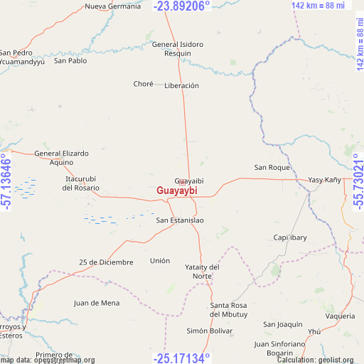
Guayaybi GPS coordinates[2]
24° 31' 59.988" South, 56° 25' 59.988" West
| Map corner | latitude | longitude |
|---|---|---|
| Upper-left | -23.89206°, | -57.13646° |
| Center: | -24.53333°, | -56.43333° |
| Lower-right: | -25.17134°, | -55.73021° |
| Map W x H: | 142.2×142.2 km | = 88.4×88.4mi |
| max Lat: | -19.91667° ⇑17.9% North |
| Guayaybi: | -24.53333° |
| min Lat: | ⇓82.1% South -27.38662° |
| min Long | Guayaybi | max Long |
| -60.78333° | -56.43333° | -54.30694° |
| W 58.6%⇐ | ⇒41.4% E |
Elevation
Elevation of Guayaybi is 284 m = 932 ft, and this is 114.3 m = 375 ft above average elevation for this country.
| Max E: |
658 m = 2159 ft | 12.3% |
| Guayaybi | 284 m 932 ft | |
| Avg. | 169.7 m = 557 ft | |
Min E: |
46 m = 151 ft | 87.7% |
See also: Paraguay elevation on elevation.city.
Geographical zone
Guayaybi is located in South temperate zone (between Tropic of Capricorn and the Antarctic Circle). Distance of this Southern Tropic circle is 121.9 km =75.7 mi to North.| Distance of | km | miles | from Guayaybi |
|---|---|---|---|
| Equator | 2727.9 | 1695 | to North |
| Tropic Capricorn | 121.9 | 75.7 | to North |
| Antarctic Circle | 4673.3 | 2903.9 | to South |
| South Pole | 7279.2 | 4523.1 | to South |


Nearby cities:
15 places around Guayaybi: (largest is in red/bold)
• Capiíbary
50.1 km =31.1 mi,  126°
126°
• Carayaó
73.9 km =45.9 mi,  177°
177°
• Cecilio Baez
62.8 km =39 mi,  162°
162°
• Chore
41.5 km =25.8 mi,  338°
338°
• Colonia Nueva Germania
74.3 km =46.2 mi, 338°
• General Elizardo Aquino
48.3 km =30 mi,  281°
281°
• Itacurubí del Rosario
39.5 km =24.5 mi,  269°
269°
• Lima
72.4 km =45 mi,  356°
356°
• Mbutuý
50.7 km =31.5 mi,  165°
165°
• Puerto Rosario
72.5 km =45 mi, 278°
• San Isidro de Curuguaty
75.3 km =46.8 mi,  84°
84°
• San Joaquín
67.7 km =42.1 mi,  144°
144°
• Unión
31.8 km =19.8 mi,  196°
196°
• Veinticinco de Diciembre
22 km =13.7 mi,  212°
212°
• Yataity del Norte
34.4 km =21.4 mi, 165°
Sources, notices
• [Note1] Compared only with cities in Paraguay existing in our database
• [Src1] Map data: © OpenStreetMap contributors (CC-BY-SA)
• [Src2] Other city data from geonames.org with taken over terms of usage.
• [Src3] Geographical zone / Annual Mean Temperature by Robert A. Rohde @ Wikipedia
