Independencia geodata
Independencia (Guairá) is a populated place; located in Paraguay in America/Asuncion (GMT-4) time zone. With population of 1,575 people, there are 123 cities with bigger population in this country. Compared to other cities in Paraguay, 59.3% of cities are located further ↑North; 65.4% of cities are located further ←West and 64.8% of cities have lower elevation than Independencia. Note1


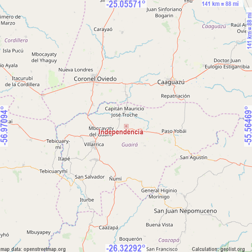
Independencia GPS coordinates[2]
25° 41' 27.6" South, 56° 16' 4.116" West
| Map corner | latitude | longitude |
|---|---|---|
| Upper-left | -25.05571°, | -56.97094° |
| Center: | -25.691°, | -56.26781° |
| Lower-right: | -26.32292°, | -55.56469° |
| Map W x H: | 140.9×140.9 km | = 87.6×87.6mi |
| max Lat: | -19.91667° ⇑59.3% North |
| Independencia: | -25.691° |
| min Lat: | ⇓40.7% South -27.38662° |
| min Long | Independencia | max Long |
| -60.78333° | -56.26781° | -54.30694° |
| W 65.4%⇐ | ⇒34.6% E |
Elevation
Elevation of Independencia is 172 m = 564 ft, and this is 2.3 m = 8 ft above average elevation for this country.
| Max E: |
658 m = 2159 ft | 35.2% |
| Independencia | 172 m 564 ft | |
| Avg. | 169.7 m = 557 ft | |
Min E: |
46 m = 151 ft | 64.8% |
See also: Paraguay elevation on elevation.city.
Geographical zone
Independencia is located in South temperate zone (between Tropic of Capricorn and the Antarctic Circle). Distance of this Southern Tropic circle is 250.7 km =155.8 mi to North.| Distance of | km | miles | from Independencia |
|---|---|---|---|
| Equator | 2856.6 | 1775 | to North |
| Tropic Capricorn | 250.7 | 155.8 | to North |
| Antarctic Circle | 4544.6 | 2823.9 | to South |
| South Pole | 7150.5 | 4443.1 | to South |


Nearby cities:
15 places around Independencia: (largest is in red/bold)
• Caaguazú
35.2 km =21.9 mi,  45°
45°
• Colonia Mauricio José Troche
13.9 km =8.6 mi,  353°
353°
• Coronel Martínez
35.8 km =22.2 mi,  257°
257°
• Coronel Oviedo
32.4 km =20.1 mi,  327°
327°
• Félix Pérez Cardozo
26.2 km =16.3 mi, 257°
• General Higinio Morínigo
45.4 km =28.2 mi,  129°
129°
• Itapé
39 km =24.2 mi,  242°
242°
• Iturbe
45.9 km =28.5 mi,  208°
208°
• Mbocayaty
15.7 km =9.8 mi, 258°
• Natalicio Talavera
7.2 km =4.5 mi, 333°
• Nueva Londres
42.6 km =26.5 mi,  318°
318°
• Repatriación
36.4 km =22.6 mi,  61°
61°
• San José
49.9 km =31 mi,  290°
290°
• Villarrica
18 km =11.2 mi,  248°
248°
• Ñumi
29.5 km =18.3 mi,  192°
192°
Sources, notices
• [Note1] Compared only with cities in Paraguay existing in our database
• [Src1] Map data: © OpenStreetMap contributors (CC-BY-SA)
• [Src2] Other city data from geonames.org with taken over terms of usage.
• [Src3] Geographical zone / Annual Mean Temperature by Robert A. Rohde @ Wikipedia
