San José geodata
San José (Caaguazú) is a populated place; located in Paraguay in America/Asuncion (GMT-4) time zone. With population of 5,117 people, there are 60 cities with bigger population in this country. Compared to other cities in Paraguay, 53.1% of cities are located further ↑North; 51.9% of cities are located further →East and 63.6% of cities have higher elevation than San José. Note1


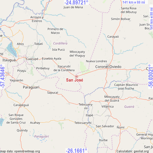
San José GPS coordinates[2]
25° 31' 59.988" South, 56° 43' 59.988" West
| Map corner | latitude | longitude |
|---|---|---|
| Upper-left | -24.89721°, | -57.43646° |
| Center: | -25.53333°, | -56.73333° |
| Lower-right: | -26.1661°, | -56.03021° |
| Map W x H: | 141.1×141.1 km | = 87.7×87.7mi |
| max Lat: | -19.91667° ⇑53.1% North |
| San José: | -25.53333° |
| min Lat: | ⇓46.9% South -27.38662° |
| min Long | San José | max Long |
| -60.78333° | -56.73333° | -54.30694° |
| W 48.1%⇐ | ⇒51.9% E |
Elevation
Elevation of San José is 125 m = 410 ft, and this is 44.7 m = 147 ft below average elevation for this country.
| Max E: |
658 m = 2159 ft | 63.6% |
| Avg. | 169.7 m = 557 ft | |
| San José | 125 m = 410 ft | |
Min E: |
46 m = 151 ft | 36.4% |
See also: Paraguay elevation on elevation.city.
Geographical zone
San José is located in South temperate zone (between Tropic of Capricorn and the Antarctic Circle). Distance of this Southern Tropic circle is 233.1 km =144.8 mi to North.| Distance of | km | miles | from San José |
|---|---|---|---|
| Equator | 2839 | 1764.1 | to North |
| Tropic Capricorn | 233.1 | 144.8 | to North |
| Antarctic Circle | 4562.1 | 2834.8 | to South |
| South Pole | 7168 | 4454 | to South |


Nearby cities:
15 places around San José: (largest is in red/bold)
• Caraguatay
34.1 km =21.2 mi,  343°
343°
• Coronel Martínez
27.6 km =17.1 mi,  154°
154°
• Coronel Oviedo
31 km =19.3 mi,  71°
71°
• Eusebio Ayala
28.3 km =17.6 mi,  306°
306°
• Félix Pérez Cardozo
31.4 km =19.5 mi,  137°
137°
• Isla Pucú
30.1 km =18.7 mi,  326°
326°
• Itacurubí de la Cordillera
14.4 km =8.9 mi,  303°
303°
• Itapé
37.4 km =23.2 mi,  161°
161°
• Mbocayaty
37.5 km =23.3 mi,  123°
123°
• Nueva Londres
23.4 km =14.5 mi,  52°
52°
• Piribebuy
31.9 km =19.8 mi,  283°
283°
• Santa Elena
14.8 km =9.2 mi, 334°
• Sapucaí
26.5 km =16.5 mi,  235°
235°
• Valenzuela
15.4 km =9.6 mi, 243°
• Ybytymi
25.9 km =16.1 mi,  195°
195°
Sources, notices
• [Note1] Compared only with cities in Paraguay existing in our database
• [Src1] Map data: © OpenStreetMap contributors (CC-BY-SA)
• [Src2] Other city data from geonames.org with taken over terms of usage.
• [Src3] Geographical zone / Annual Mean Temperature by Robert A. Rohde @ Wikipedia
